Tuftonboro elevation
Tuftonboro (New Hampshire, Carroll County), United States elevation is 306 meters and Tuftonboro elevation in feet is 1004 ft above sea level [src 1]. Tuftonboro is a populated place (feature code) with elevation that is 27 meters (89 ft) bigger than average city elevation in United States.
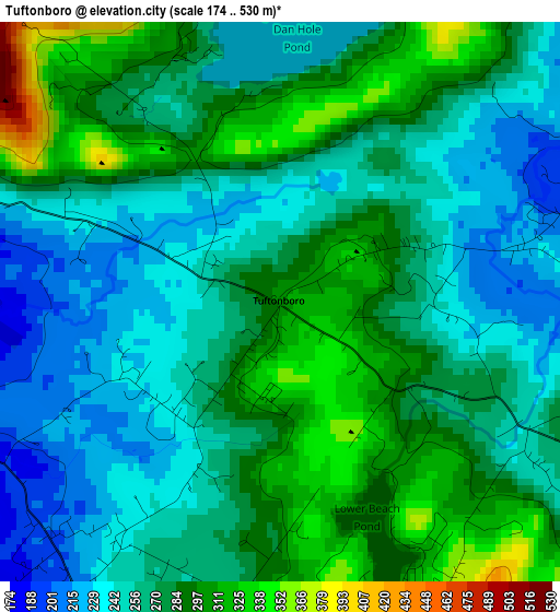
Below is the Elevation map of Tuftonboro, which displays elevation range with different colors. Scale of the first map is from 174 to 530 m (571 to 1739 ft) with average elevation of 271.3 meters (=890 ft) [note 1]
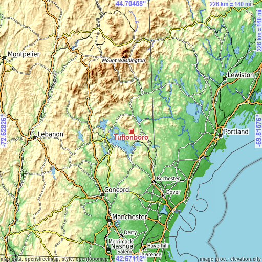
These maps also provides idea of topography and contour of this city, they are displayed at different zoom levels. More info about maps, scale and edge coordinates you can find below images.
| \ | Map #1 | Topo.Map |
| Scale [m] | 174..530 m | × |
| Scale [ft] | 571..1739 ft | × |
| Average | 271.3 m = 890 ft | × |
| Width | 7.07 km = 4.4 mi | 226.1 km = 140.5 mi |
| Height | 7.07 km = 4.4 mi | 226.1 km = 140.5 mi |
| ↑Max Latitude | 43.728234° | 44.70458° |
| Latitude at center | 43.69647° | 43.69647° |
| ↓Min Latitude | 43.664689° | 42.67112° |
| ← Min Longitude | -71.265955° | -72.62826° |
| Longitude center | -71.22201° | -71.22201° |
| →Max Longitude | -71.178065° | -69.81576° |
Nearby cities:
Cities around Tuftonboro sort by population:
• Gilford elevation 228 m
22.3 km,  221°
221°
• Moultonborough 188 m
15.5 km,  294°
294°
• Wakefield 210 m
21 km,  132°
132°
• Ossipee 208 m
8.6 km,  98°
98°
• Wolfeboro 172 m
12.6 km,  174°
174°
• Tamworth 159 m
18.5 km,  349°
349°
• Meredith 157 m
22.8 km,  259°
259°
• Freedom 145 m
19.7 km,  49°
49°
• Sandwich 240 m
18.4 km,  304°
304°
• Effingham 183 m
19.5 km,  68°
68°
• Center Harbor 158 m
19.2 km,  274°
274°
• Sanbornville 176 m
22.1 km,  135°
135°
Multilingual:
 En español:
Tuftonboro elevación 306 m.
 En France:
Tuftonboro élévation 306 m.
 Auf Deutsch:
Tuftonboro höhe über dem Meeresspiegel ist 306 m.

Sources and notes:
- [note 1] Map square and city borders are not equal. Map elevation data is calculated only from area inside that square.
- [src 1] Elevation data from geonames database provided with same terms of usage.
- [src 2] The elevation map of Tuftonboro is generated using elevation data from NASA's 3 arcsec (90m) resolution SRTM data.
- [src 3] Base (background) map © OpenStreetMap contributors tiles are generated by Geofabrik and OpenTopoMap.
Copyright & License:
This Tuftonboro Elevation Map is licensed under CC BY-SA. You may reuse any part from this page, if you give a proper credit by linking to this URL:
 More info on terms of use page.