Tamworth elevation
Tamworth (New Hampshire, Carroll County), United States elevation is 159 meters and Tamworth elevation in feet is 522 ft above sea level [src 1]. Tamworth is a populated place (feature code) with elevation that is 120 meters (394 ft) smaller than average city elevation in United States.
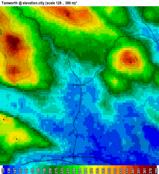
Below is the Elevation map of Tamworth, which displays elevation range with different colors. Scale of the first map is from 128 to 380 m (420 to 1247 ft) with average elevation of 207.3 meters (=680 ft) [note 1]
These maps also provides idea of topography and contour of this city, they are displayed at different zoom levels. More info about maps, scale and edge coordinates you can find below images.
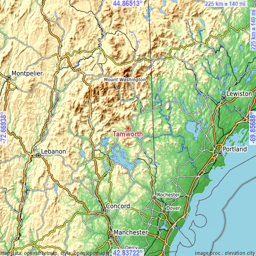
| \ | Map #1 | Topo.Map |
| Scale [m] | 128..380 m | × |
| Scale [ft] | 420..1247 ft | × |
| Average | 207.3 m = 680 ft | × |
| Width | 7.05 km = 4.4 mi | 225.5 km = 140.1 mi |
| Height | 7.05 km = 4.4 mi | 225.5 km = 140.1 mi |
| ↑Max Latitude | 43.891478° | 44.86513° |
| Latitude at center | 43.8598° | 43.8598° |
| ↓Min Latitude | 43.828105° | 42.83722° |
| ← Min Longitude | -71.307075° | -72.66938° |
| Longitude center | -71.26313° | -71.26313° |
| →Max Longitude | -71.219185° | -69.85688° |
Nearby cities:
Cities around Tamworth sort by population:
• Moultonborough elevation 188 m
15.9 km,  222°
222°
• Ossipee 208 m
22.7 km,  148°
148°
• North Conway 163 m
24.1 km,  26°
26°
• Tuftonboro 306 m
18.5 km,  169°
169°
• Madison 175 m
10.2 km,  64°
64°
• Conway 142 m
17.5 km,  40°
40°
• Fryeburg 131 m
28.5 km,  52°
52°
• Porter 125 m
27.5 km,  104°
104°
• Freedom 145 m
19 km,  106°
106°
• Sandwich 240 m
14.2 km,  236°
236°
• Effingham 183 m
24 km,  117°
117°
• Center Harbor 158 m
23 km, 223°
Multilingual:
 En español:
Tamworth elevación 159 m.
 En France:
Tamworth élévation 159 m.
 Auf Deutsch:
Tamworth höhe über dem Meeresspiegel ist 159 m.

Sources and notes:
- [note 1] Map square and city borders are not equal. Map elevation data is calculated only from area inside that square.
- [src 1] Elevation data from geonames database provided with same terms of usage.
- [src 2] The elevation map of Tamworth is generated using elevation data from NASA's 3 arcsec (90m) resolution SRTM data.
- [src 3] Base (background) map © OpenStreetMap contributors tiles are generated by Geofabrik and OpenTopoMap.
Copyright & License:
This Tamworth Elevation Map is licensed under CC BY-SA. You may reuse any part from this page, if you give a proper credit by linking to this URL:
 More info on terms of use page.