Moultonborough elevation
Moultonborough (New Hampshire, Carroll County), United States elevation is 188 meters and Moultonborough elevation in feet is 617 ft above sea level [src 1]. Moultonborough is a populated place (feature code) with elevation that is 91 meters (299 ft) smaller than average city elevation in United States.
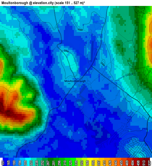
Below is the Elevation map of Moultonborough, which displays elevation range with different colors. Scale of the first map is from 151 to 527 m (495 to 1729 ft) with average elevation of 217.2 meters (=713 ft) [note 1]
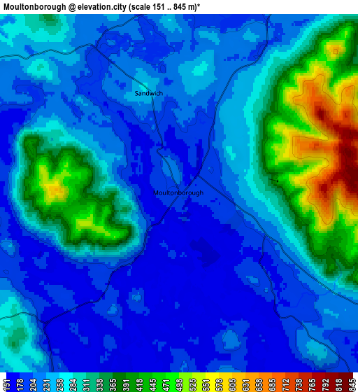
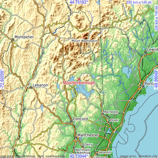
These maps also provides idea of topography and contour of this city, they are displayed at different zoom levels. More info about maps, scale and edge coordinates you can find below images.
| \ | Map #1 | Map #2 | Topo.Map |
| Scale [m] | 151..527 m | 151..845 m | × |
| Scale [ft] | 495..1729 ft | 495..2772 ft | × |
| Average | 217.2 m = 713 ft | 267.7 m = 878 ft | × |
| Width | 7.06 km = 4.4 mi | 14.12 km = 8.8 mi | 225.9 km = 140.4 mi |
| Height | 7.06 km = 4.4 mi | 14.12 km = 8.8 mi | 225.9 km = 140.4 mi |
| ↑Max Latitude | 43.786534° | 43.81825° | 44.76192° |
| Latitude at center | 43.7548° | 43.7548° | 43.7548° |
| ↓Min Latitude | 43.72305° | 43.691282° | 42.73044° |
| ← Min Longitude | -71.440685° | -71.484631° | -72.80299° |
| Longitude center | -71.39674° | -71.39674° | -71.39674° |
| →Max Longitude | -71.352795° | -71.308849° | -69.99049° |
Nearby cities:
Cities around Moultonborough sort by population:
• Gilford elevation 228 m
23.1 km,  181°
181°
• Ossipee 208 m
23.8 km,  108°
108°
• Plymouth 163 m
23.4 km,  270°
270°
• Wolfeboro 172 m
24.4 km,  141°
141°
• Tamworth 159 m
15.9 km,  42°
42°
• Tuftonboro 306 m
15.5 km, 114°
• Madison 175 m
25.6 km,  51°
51°
• Holderness 181 m
15.6 km,  260°
260°
• Meredith 157 m
13.6 km,  217°
217°
• Sandwich 240 m
4.1 km,  343°
343°
• Ashland 173 m
19.9 km,  250°
250°
• Center Harbor 158 m
7.2 km,  225°
225°
Multilingual:
 En español:
Moultonborough elevación 188 m.
 En France:
Moultonborough élévation 188 m.
 Auf Deutsch:
Moultonborough höhe über dem Meeresspiegel ist 188 m.

Sources and notes:
- [note 1] Map square and city borders are not equal. Map elevation data is calculated only from area inside that square.
- [src 1] Elevation data from geonames database provided with same terms of usage.
- [src 2] The elevation map of Moultonborough is generated using elevation data from NASA's 3 arcsec (90m) resolution SRTM data.
- [src 3] Base (background) map © OpenStreetMap contributors tiles are generated by Geofabrik and OpenTopoMap.
Copyright & License:
This Moultonborough Elevation Map is licensed under CC BY-SA. You may reuse any part from this page, if you give a proper credit by linking to this URL:
 More info on terms of use page.