Ashland elevation
Ashland (New Hampshire, Grafton County), United States elevation is 173 meters and Ashland elevation in feet is 568 ft above sea level [src 1]. Ashland is a populated place (feature code) with elevation that is 106 meters (348 ft) smaller than average city elevation in United States.
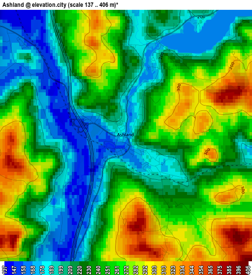
Below is the Elevation map of Ashland, which displays elevation range with different colors. Scale of the first map is from 137 to 406 m (449 to 1332 ft) with average elevation of 238.4 meters (=782 ft) [note 1]
These maps also provides idea of topography and contour of this city, they are displayed at different zoom levels. More info about maps, scale and edge coordinates you can find below images.
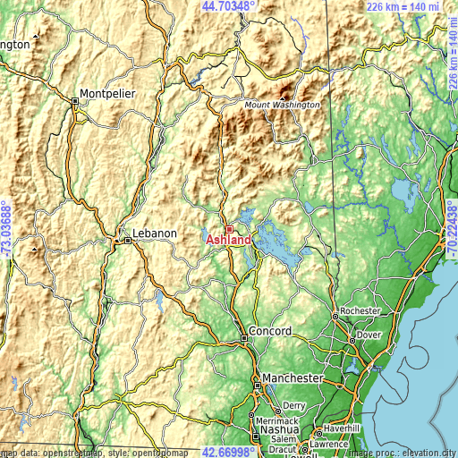
| \ | Map #1 | Topo.Map |
| Scale [m] | 137..406 m | × |
| Scale [ft] | 449..1332 ft | × |
| Average | 238.4 m = 782 ft | × |
| Width | 7.07 km = 4.4 mi | 226.1 km = 140.5 mi |
| Height | 7.07 km = 4.4 mi | 226.1 km = 140.5 mi |
| ↑Max Latitude | 43.727115° | 44.70348° |
| Latitude at center | 43.69535° | 43.69535° |
| ↓Min Latitude | 43.663568° | 42.66998° |
| ← Min Longitude | -71.674575° | -73.03688° |
| Longitude center | -71.63063° | -71.63063° |
| →Max Longitude | -71.586685° | -70.22438° |
Nearby cities:
Cities around Ashland sort by population:
• Moultonborough elevation 188 m
19.9 km,  70°
70°
• Plymouth 163 m
8.3 km,  326°
326°
• Holderness 181 m
5.3 km,  39°
39°
• Thornton 203 m
22.3 km,  350°
350°
• Meredith 157 m
11.3 km,  111°
111°
• Bristol 141 m
14.4 km,  216°
216°
• Rumney 159 m
19.1 km,  309°
309°
• Alexandria 190 m
16 km,  234°
234°
• Sandwich 240 m
20.6 km,  59°
59°
• Center Harbor 158 m
13.8 km,  83°
83°
• Hill 143 m
19.8 km,  196°
196°
• Bridgewater 201 m
10.6 km, 233°
Multilingual:
 En español:
Ashland elevación 173 m.
 En France:
Ashland élévation 173 m.


Sources and notes:
- [note 1] Map square and city borders are not equal. Map elevation data is calculated only from area inside that square.
- [src 1] Elevation data from geonames database provided with same terms of usage.
- [src 2] The elevation map of Ashland is generated using elevation data from NASA's 3 arcsec (90m) resolution SRTM data.
- [src 3] Base (background) map © OpenStreetMap contributors tiles are generated by Geofabrik and OpenTopoMap.
Copyright & License:
This Ashland Elevation Map is licensed under CC BY-SA. You may reuse any part from this page, if you give a proper credit by linking to this URL:
 More info on terms of use page.