Oakland elevation
Oakland (Nebraska, Burt County), United States elevation is 393 meters and Oakland elevation in feet is 1289 ft above sea level [src 1]. Oakland is a populated place (feature code) with elevation that is 114 meters (374 ft) bigger than average city elevation in United States.
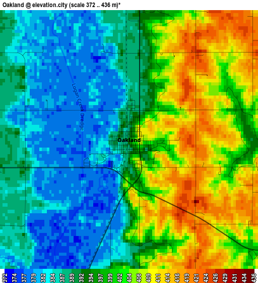
Below is the Elevation map of Oakland, which displays elevation range with different colors. Scale of the first map is from 372 to 436 m (1220 to 1430 ft) with average elevation of 395.2 meters (=1297 ft) [note 1]
These maps also provides idea of topography and contour of this city, they are displayed at different zoom levels. More info about maps, scale and edge coordinates you can find below images.
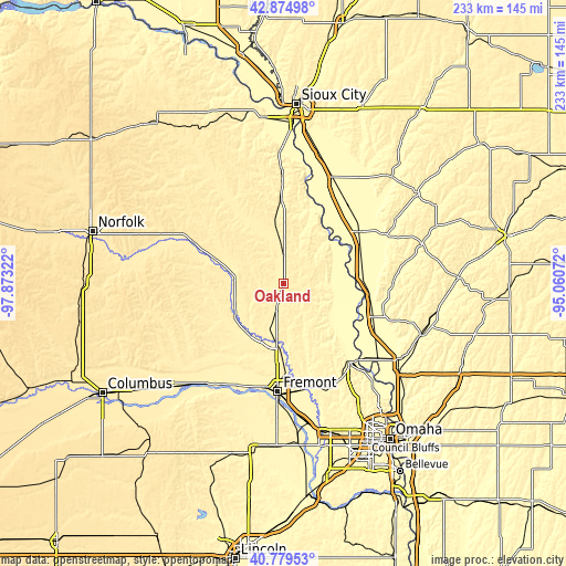
| \ | Map #1 | Topo.Map |
| Scale [m] | 372..436 m | × |
| Scale [ft] | 1220..1430 ft | × |
| Average | 395.2 m = 1297 ft | × |
| Width | 7.28 km = 4.5 mi | 233 km = 144.8 mi |
| Height | 7.28 km = 4.5 mi | 233 km = 144.8 mi |
| ↑Max Latitude | 41.868563° | 42.87498° |
| Latitude at center | 41.83583° | 41.83583° |
| ↓Min Latitude | 41.80308° | 40.77953° |
| ← Min Longitude | -96.510915° | -97.87322° |
| Longitude center | -96.46697° | -96.46697° |
| →Max Longitude | -96.423025° | -95.06072° |
Nearby cities:
Cities around Oakland sort by population:
• Fremont elevation 366 m
44.8 km,  183°
183°
• Blair 327 m
43.1 km,  138°
138°
• West Point 414 m
20 km,  271°
271°
• Onawa 319 m
37.2 km,  55°
55°
• Missouri Valley 311 m
57.3 km,  122°
122°
• Tekamah 319 m
21.4 km,  107°
107°
• Wakefield 429 m
58.3 km,  325°
325°
• Arlington 360 m
43.7 km,  167°
167°
• North Bend 390 m
49 km,  212°
212°
• Wisner 422 m
40.7 km,  294°
294°
• Pender 408 m
36.8 km, 327°
• Macy 343 m
32.2 km,  16°
16°
Multilingual:
 En español:
Oakland elevación 393 m.
 En France:
Oakland élévation 393 m.


Sources and notes:
- [note 1] Map square and city borders are not equal. Map elevation data is calculated only from area inside that square.
- [src 1] Elevation data from geonames database provided with same terms of usage.
- [src 2] The elevation map of Oakland is generated using elevation data from NASA's 3 arcsec (90m) resolution SRTM data.
- [src 3] Base (background) map © OpenStreetMap contributors tiles are generated by Geofabrik and OpenTopoMap.
Copyright & License:
This Oakland Elevation Map is licensed under CC BY-SA. You may reuse any part from this page, if you give a proper credit by linking to this URL:
 More info on terms of use page.