Wakefield elevation
Wakefield (Nebraska, Dixon County), United States elevation is 429 meters and Wakefield elevation in feet is 1407 ft above sea level [src 1]. Wakefield is a populated place (feature code) with elevation that is 150 meters (492 ft) bigger than average city elevation in United States.
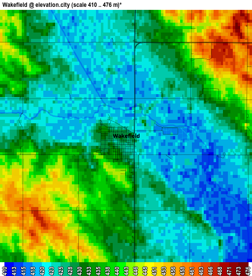
Below is the Elevation map of Wakefield, which displays elevation range with different colors. Scale of the first map is from 410 to 476 m (1345 to 1562 ft) with average elevation of 431.4 meters (=1415 ft) [note 1]
These maps also provides idea of topography and contour of this city, they are displayed at different zoom levels. More info about maps, scale and edge coordinates you can find below images.
| \ | Map #1 | Topo.Map |
| Scale [m] | 410..476 m | × |
| Scale [ft] | 1345..1562 ft | × |
| Average | 431.4 m = 1415 ft | × |
| Width | 7.23 km = 4.5 mi | 231.4 km = 143.8 mi |
| Height | 7.23 km = 4.5 mi | 231.4 km = 143.8 mi |
| ↑Max Latitude | 42.301681° | 43.30119° |
| Latitude at center | 42.26917° | 42.26917° |
| ↓Min Latitude | 42.236642° | 41.21998° |
| ← Min Longitude | -96.908985° | -98.27129° |
| Longitude center | -96.86504° | -96.86504° |
| →Max Longitude | -96.821095° | -95.45879° |
Nearby cities:
Cities around Wakefield sort by population:
• Sioux City elevation 364 m
46 km,  56°
56°
• South Sioux City 333 m
43.5 km, 58°
• Wayne 441 m
13.3 km,  251°
251°
• Sergeant Bluff 331 m
44.2 km,  70°
70°
• North Sioux City 333 m
42.5 km,  47°
47°
• Dakota Dunes 336 m
39.5 km, 52°
• Dakota City 333 m
40.2 km, 66°
• Stanton 450 m
46.2 km,  219°
219°
• Wisner 422 m
31.6 km,  187°
187°
• Pender 408 m
21.6 km,  142°
142°
• Macy 343 m
45.4 km,  112°
112°
• Ponca 346 m
35.1 km,  21°
21°
Multilingual:
 En español:
Wakefield elevación 429 m.
 En France:
Wakefield élévation 429 m.
 Auf Deutsch:
Wakefield höhe über dem Meeresspiegel ist 429 m.

Sources and notes:
- [note 1] Map square and city borders are not equal. Map elevation data is calculated only from area inside that square.
- [src 1] Elevation data from geonames database provided with same terms of usage.
- [src 2] The elevation map of Wakefield is generated using elevation data from NASA's 3 arcsec (90m) resolution SRTM data.
- [src 3] Base (background) map © OpenStreetMap contributors tiles are generated by Geofabrik and OpenTopoMap.
Copyright & License:
This Wakefield Elevation Map is licensed under CC BY-SA. You may reuse any part from this page, if you give a proper credit by linking to this URL:
 More info on terms of use page.