Macy elevation
Macy (Nebraska, Thurston County), United States elevation is 343 meters and Macy elevation in feet is 1125 ft above sea level [src 1]. Macy is a populated place (feature code) with elevation that is 64 meters (210 ft) bigger than average city elevation in United States.
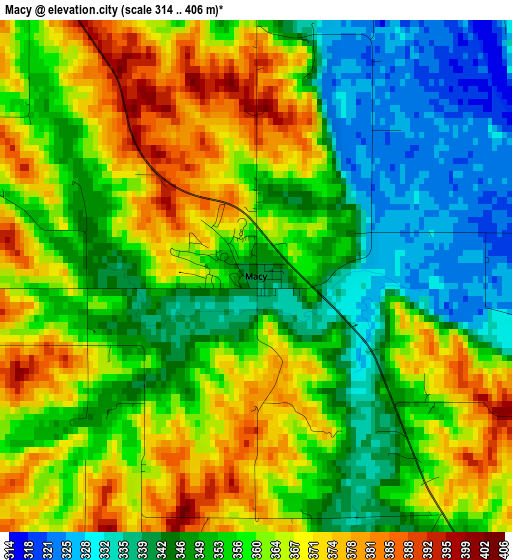
Below is the Elevation map of Macy, which displays elevation range with different colors. Scale of the first map is from 314 to 406 m (1030 to 1332 ft) with average elevation of 356.5 meters (=1170 ft) [note 1]
These maps also provides idea of topography and contour of this city, they are displayed at different zoom levels. More info about maps, scale and edge coordinates you can find below images.
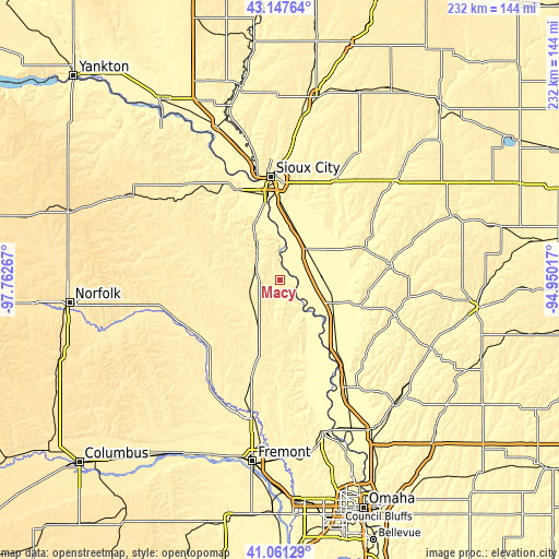
| \ | Map #1 | Topo.Map |
| Scale [m] | 314..406 m | × |
| Scale [ft] | 1030..1332 ft | × |
| Average | 356.5 m = 1170 ft | × |
| Width | 7.25 km = 4.5 mi | 232 km = 144.2 mi |
| Height | 7.25 km = 4.5 mi | 232 km = 144.2 mi |
| ↑Max Latitude | 42.145641° | 43.14764° |
| Latitude at center | 42.11305° | 42.11305° |
| ↓Min Latitude | 42.080442° | 41.06129° |
| ← Min Longitude | -96.400365° | -97.76267° |
| Longitude center | -96.35642° | -96.35642° |
| →Max Longitude | -96.312475° | -94.95017° |
Nearby cities:
Cities around Macy sort by population:
• Sioux City elevation 364 m
43.2 km,  355°
355°
• South Sioux City 333 m
40.4 km,  353°
353°
• Sergeant Bluff 331 m
32.3 km, 359°
• West Point 414 m
41.9 km,  223°
223°
• Onawa 319 m
23.5 km,  114°
114°
• Dakota Dunes 336 m
43 km, 345°
• Dakota City 333 m
34 km, 351°
• Tekamah 319 m
38.9 km,  163°
163°
• Wakefield 429 m
45.4 km,  292°
292°
• Mapleton 346 m
46.8 km,  82°
82°
• Oakland 393 m
32.2 km,  196°
196°
• Pender 408 m
28.9 km,  270°
270°
Multilingual:
 En español:
Macy elevación 343 m.
 En France:
Macy élévation 343 m.


Sources and notes:
- [note 1] Map square and city borders are not equal. Map elevation data is calculated only from area inside that square.
- [src 1] Elevation data from geonames database provided with same terms of usage.
- [src 2] The elevation map of Macy is generated using elevation data from NASA's 3 arcsec (90m) resolution SRTM data.
- [src 3] Base (background) map © OpenStreetMap contributors tiles are generated by Geofabrik and OpenTopoMap.
Copyright & License:
This Macy Elevation Map is licensed under CC BY-SA. You may reuse any part from this page, if you give a proper credit by linking to this URL:
 More info on terms of use page.