Onawa elevation
Onawa (Iowa, Monona County), United States elevation is 319 meters and Onawa elevation in feet is 1047 ft above sea level [src 1]. Onawa is a seat of a second-order administrative division (feature code) with elevation that is 40 meters (131 ft) bigger than average city elevation in United States.
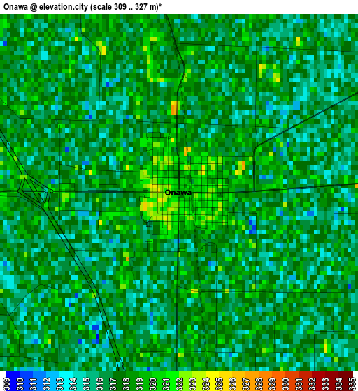
Below is the Elevation map of Onawa, which displays elevation range with different colors. Scale of the first map is from 309 to 327 m (1014 to 1073 ft) with average elevation of 316.9 meters (=1040 ft) [note 1]
These maps also provides idea of topography and contour of this city, they are displayed at different zoom levels. More info about maps, scale and edge coordinates you can find below images.
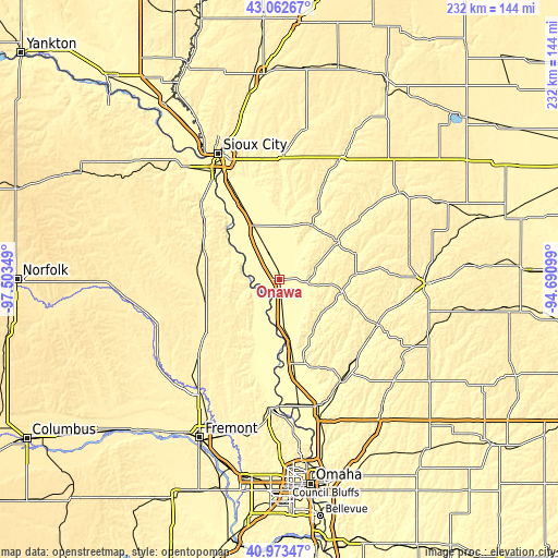
| \ | Map #1 | Topo.Map |
| Scale [m] | 309..327 m | × |
| Scale [ft] | 1014..1073 ft | × |
| Average | 316.9 m = 1040 ft | × |
| Width | 7.26 km = 4.5 mi | 232.3 km = 144.3 mi |
| Height | 7.26 km = 4.5 mi | 232.3 km = 144.3 mi |
| ↑Max Latitude | 42.059286° | 43.06267° |
| Latitude at center | 42.02665° | 42.02665° |
| ↓Min Latitude | 41.993998° | 40.97347° |
| ← Min Longitude | -96.141185° | -97.50349° |
| Longitude center | -96.09724° | -96.09724° |
| →Max Longitude | -96.053295° | -94.69099° |
Nearby cities:
Cities around Onawa sort by population:
• Blair elevation 327 m
53.7 km,  182°
182°
• Sergeant Bluff 331 m
47.1 km,  332°
332°
• West Point 414 m
54.6 km,  247°
247°
• Dakota City 333 m
50.7 km, 328°
• Tekamah 319 m
29.5 km,  200°
200°
• Moville 358 m
51.4 km,  2°
2°
• Logan 334 m
49.7 km,  149°
149°
• Woodbine 333 m
45.8 km,  134°
134°
• Mapleton 346 m
29.5 km,  58°
58°
• Oakland 393 m
37.2 km,  235°
235°
• Pender 408 m
51.3 km,  280°
280°
• Macy 343 m
23.5 km,  294°
294°
Multilingual:
 En español:
Onawa elevación 319 m.
 En France:
Onawa élévation 319 m.


Sources and notes:
- [note 1] Map square and city borders are not equal. Map elevation data is calculated only from area inside that square.
- [src 1] Elevation data from geonames database provided with same terms of usage.
- [src 2] The elevation map of Onawa is generated using elevation data from NASA's 3 arcsec (90m) resolution SRTM data.
- [src 3] Base (background) map © OpenStreetMap contributors tiles are generated by Geofabrik and OpenTopoMap.
Copyright & License:
This Onawa Elevation Map is licensed under CC BY-SA. You may reuse any part from this page, if you give a proper credit by linking to this URL:
 More info on terms of use page.