Blair elevation
Blair (Nebraska, Washington County), United States elevation is 327 meters and Blair elevation in feet is 1073 ft above sea level [src 1]. Blair is a seat of a second-order administrative division (feature code) with elevation that is 48 meters (157 ft) bigger than average city elevation in United States.
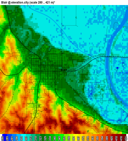
Below is the Elevation map of Blair, which displays elevation range with different colors. Scale of the first map is from 280 to 421 m (919 to 1381 ft) with average elevation of 332.6 meters (=1091 ft) [note 1]
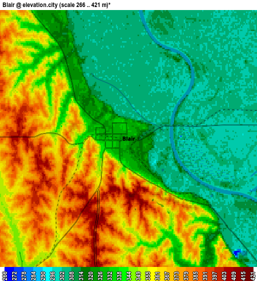
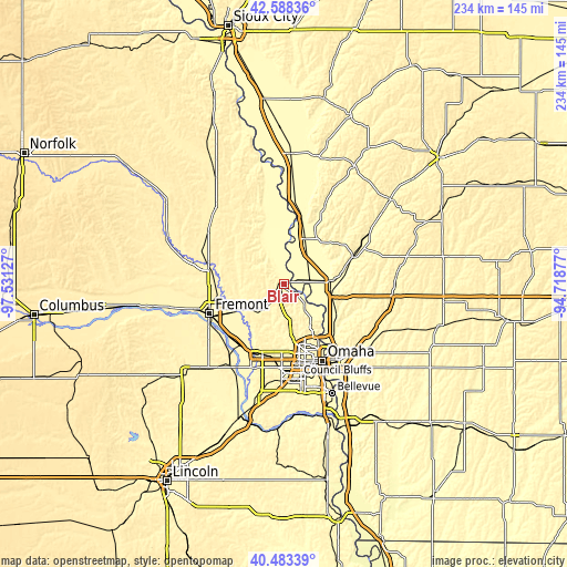
These maps also provides idea of topography and contour of this city, they are displayed at different zoom levels. More info about maps, scale and edge coordinates you can find below images.
| \ | Map #1 | Map #2 | Topo.Map |
| Scale [m] | 280..421 m | 266..421 m | × |
| Scale [ft] | 919..1381 ft | 873..1381 ft | × |
| Average | 332.6 m = 1091 ft | 336.9 m = 1105 ft | × |
| Width | 7.31 km = 4.5 mi | 14.63 km = 9.1 mi | 234.1 km = 145.5 mi |
| Height | 7.31 km = 4.5 mi | 14.63 km = 9.1 mi | 234 km = 145.4 mi |
| ↑Max Latitude | 41.577322° | 41.610188° | 42.58836° |
| Latitude at center | 41.54444° | 41.54444° | 41.54444° |
| ↓Min Latitude | 41.511541° | 41.478626° | 40.48339° |
| ← Min Longitude | -96.168965° | -96.212911° | -97.53127° |
| Longitude center | -96.12502° | -96.12502° | -96.12502° |
| →Max Longitude | -96.081075° | -96.037129° | -94.71877° |
Nearby cities:
Cities around Blair sort by population:
• Omaha elevation 315 m
35.5 km,  154°
154°
• Fremont 366 m
33.4 km,  248°
248°
• Elkhorn 375 m
30.1 km,  197°
197°
• Ralston 348 m
38.3 km,  169°
169°
• Carter Lake 296 m
33.1 km, 148°
• Missouri Valley 311 m
19.8 km,  86°
86°
• Valley 348 m
31.7 km,  215°
215°
• Tekamah 319 m
27.2 km,  342°
342°
• Bennington 339 m
20.2 km,  187°
187°
• Logan 334 m
30 km,  68°
68°
• Arlington 360 m
21.4 km,  241°
241°
• Waterloo 343 m
31.6 km,  205°
205°
Multilingual:
 En español:
Blair elevación 327 m.
 En France:
Blair élévation 327 m.


Sources and notes:
- [note 1] Map square and city borders are not equal. Map elevation data is calculated only from area inside that square.
- [src 1] Elevation data from geonames database provided with same terms of usage.
- [src 2] The elevation map of Blair is generated using elevation data from NASA's 3 arcsec (90m) resolution SRTM data.
- [src 3] Base (background) map © OpenStreetMap contributors tiles are generated by Geofabrik and OpenTopoMap.
Copyright & License:
This Blair Elevation Map is licensed under CC BY-SA. You may reuse any part from this page, if you give a proper credit by linking to this URL:
 More info on terms of use page.