Abingdon elevation
Abingdon (Illinois, Knox County), United States elevation is 231 meters and Abingdon elevation in feet is 758 ft above sea level [src 1]. Abingdon is a populated place (feature code) with elevation that is 48 meters (157 ft) smaller than average city elevation in United States.
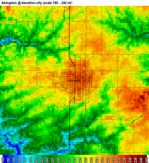
Below is the Elevation map of Abingdon, which displays elevation range with different colors. Scale of the first map is from 189 to 242 m (620 to 794 ft) with average elevation of 216.9 meters (=712 ft) [note 1]
These maps also provides idea of topography and contour of this city, they are displayed at different zoom levels. More info about maps, scale and edge coordinates you can find below images.
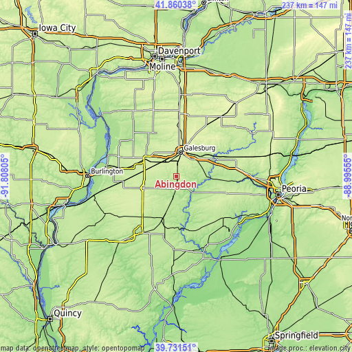
| \ | Map #1 | Topo.Map |
| Scale [m] | 189..242 m | × |
| Scale [ft] | 620..794 ft | × |
| Average | 216.9 m = 712 ft | × |
| Width | 7.4 km = 4.6 mi | 236.7 km = 147.1 mi |
| Height | 7.4 km = 4.6 mi | 236.7 km = 147.1 mi |
| ↑Max Latitude | 40.837736° | 41.86038° |
| Latitude at center | 40.80448° | 40.80448° |
| ↓Min Latitude | 40.771208° | 39.73151° |
| ← Min Longitude | -90.445745° | -91.80805° |
| Longitude center | -90.4018° | -90.4018° |
| →Max Longitude | -90.357855° | -88.99555° |
Nearby cities:
Cities around Abingdon sort by population:
• Galesburg elevation 237 m
16.1 km,  9°
9°
• Macomb 216 m
44.6 km,  210°
210°
• Canton 200 m
41.3 km,  131°
131°
• Monmouth 236 m
23.8 km,  299°
299°
• Bushnell 203 m
29.3 km,  197°
197°
• Knoxville 239 m
15.2 km,  40°
40°
• Galva 260 m
50.4 km, 36°
• Farmington 228 m
35.4 km,  109°
109°
• Lewistown 180 m
50.3 km,  155°
155°
• Elmwood 195 m
36.8 km,  94°
94°
• Oquawka 170 m
48 km,  287°
287°
• Cuba 208 m
39 km,  152°
152°
Multilingual:
 En español:
Abingdon elevación 231 m.
 En France:
Abingdon élévation 231 m.
 Auf Deutsch:
Abingdon höhe über dem Meeresspiegel ist 231 m.

Sources and notes:
- [note 1] Map square and city borders are not equal. Map elevation data is calculated only from area inside that square.
- [src 1] Elevation data from geonames database provided with same terms of usage.
- [src 2] The elevation map of Abingdon is generated using elevation data from NASA's 3 arcsec (90m) resolution SRTM data.
- [src 3] Base (background) map © OpenStreetMap contributors tiles are generated by Geofabrik and OpenTopoMap.
Copyright & License:
This Abingdon Elevation Map is licensed under CC BY-SA. You may reuse any part from this page, if you give a proper credit by linking to this URL:
 More info on terms of use page.