Lewistown elevation
Lewistown (Illinois, Fulton County), United States elevation is 180 meters and Lewistown elevation in feet is 591 ft above sea level [src 1]. Lewistown is a seat of a second-order administrative division (feature code) with elevation that is 99 meters (325 ft) smaller than average city elevation in United States.
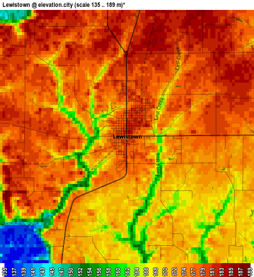
Below is the Elevation map of Lewistown, which displays elevation range with different colors. Scale of the first map is from 135 to 189 m (443 to 620 ft) with average elevation of 173.8 meters (=570 ft) [note 1]
These maps also provides idea of topography and contour of this city, they are displayed at different zoom levels. More info about maps, scale and edge coordinates you can find below images.
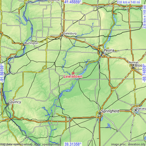
| \ | Map #1 | Topo.Map |
| Scale [m] | 135..189 m | × |
| Scale [ft] | 443..620 ft | × |
| Average | 173.8 m = 570 ft | × |
| Width | 7.44 km = 4.6 mi | 238.2 km = 148 mi |
| Height | 7.44 km = 4.6 mi | 238.2 km = 148 mi |
| ↑Max Latitude | 40.426561° | 41.45559° |
| Latitude at center | 40.3931° | 40.3931° |
| ↓Min Latitude | 40.359622° | 39.31358° |
| ← Min Longitude | -90.198785° | -91.56109° |
| Longitude center | -90.15484° | -90.15484° |
| →Max Longitude | -90.110895° | -88.74859° |
Nearby cities:
Cities around Lewistown sort by population:
• Macomb elevation 216 m
44.4 km,  279°
279°
• Canton 200 m
21 km,  28°
28°
• Havana 150 m
13.1 km,  142°
142°
• Bushnell 203 m
34.6 km,  300°
300°
• Farmington 228 m
36.2 km,  20°
20°
• Mason City 175 m
44.2 km,  118°
118°
• Lake Camelot 184 m
43.8 km,  52°
52°
• Manito 153 m
32 km,  83°
83°
• Cuba 208 m
11.5 km,  344°
344°
• South Pekin 158 m
44 km, 75°
• Astoria 217 m
25.3 km,  223°
223°
• Glasford 188 m
35.1 km,  55°
55°
Multilingual:
 En español:
Lewistown elevación 180 m.
 En France:
Lewistown élévation 180 m.
 Auf Deutsch:
Lewistown höhe über dem Meeresspiegel ist 180 m.

Sources and notes:
- [note 1] Map square and city borders are not equal. Map elevation data is calculated only from area inside that square.
- [src 1] Elevation data from geonames database provided with same terms of usage.
- [src 2] The elevation map of Lewistown is generated using elevation data from NASA's 3 arcsec (90m) resolution SRTM data.
- [src 3] Base (background) map © OpenStreetMap contributors tiles are generated by Geofabrik and OpenTopoMap.
Copyright & License:
This Lewistown Elevation Map is licensed under CC BY-SA. You may reuse any part from this page, if you give a proper credit by linking to this URL:
 More info on terms of use page.