Manning elevation
Manning (Iowa, Carroll County), United States elevation is 409 meters and Manning elevation in feet is 1342 ft above sea level [src 1]. Manning is a populated place (feature code) with elevation that is 130 meters (427 ft) bigger than average city elevation in United States.
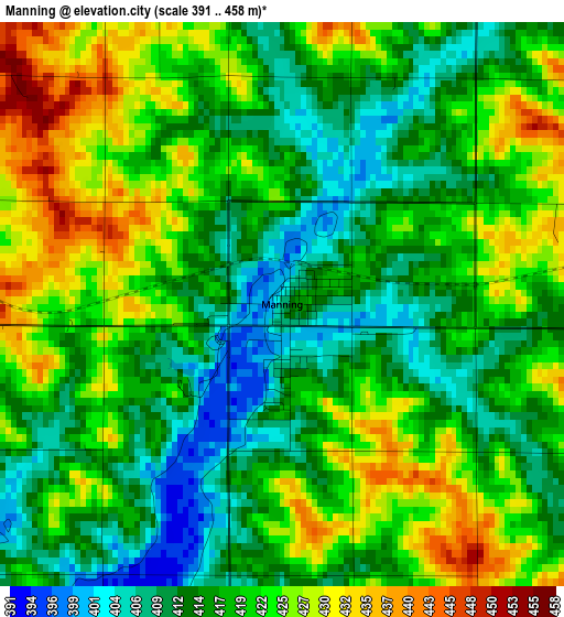
Below is the Elevation map of Manning, which displays elevation range with different colors. Scale of the first map is from 391 to 458 m (1283 to 1503 ft) with average elevation of 418.8 meters (=1374 ft) [note 1]
These maps also provides idea of topography and contour of this city, they are displayed at different zoom levels. More info about maps, scale and edge coordinates you can find below images.
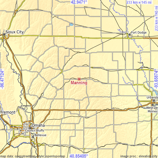
| \ | Map #1 | Topo.Map |
| Scale [m] | 391..458 m | × |
| Scale [ft] | 1283..1503 ft | × |
| Average | 418.8 m = 1374 ft | × |
| Width | 7.27 km = 4.5 mi | 232.7 km = 144.6 mi |
| Height | 7.27 km = 4.5 mi | 232.7 km = 144.6 mi |
| ↑Max Latitude | 41.941846° | 42.9471° |
| Latitude at center | 41.90915° | 41.90915° |
| ↓Min Latitude | 41.876437° | 40.85405° |
| ← Min Longitude | -95.108935° | -96.47124° |
| Longitude center | -95.06499° | -95.06499° |
| →Max Longitude | -95.021045° | -93.65874° |
Nearby cities:
Cities around Manning sort by population:
• Carroll elevation 385 m
23.9 km,  43°
43°
• Denison 391 m
26.9 km,  296°
296°
• Atlantic 372 m
56.4 km,  175°
175°
• Harlan 385 m
35.7 km,  217°
217°
• Audubon 397 m
23.9 km,  152°
152°
• Lake City 374 m
48.3 km,  34°
34°
• Guthrie Center 339 m
53.2 km,  118°
118°
• Avoca 360 m
53.2 km,  205°
205°
• Woodbine 333 m
56.2 km,  250°
250°
• Coon Rapids 354 m
32.4 km,  97°
97°
• Glidden 372 m
32.3 km,  59°
59°
• Lake View 380 m
44.8 km,  1°
1°
Multilingual:
 En español:
Manning elevación 409 m.
 En France:
Manning élévation 409 m.


Sources and notes:
- [note 1] Map square and city borders are not equal. Map elevation data is calculated only from area inside that square.
- [src 1] Elevation data from geonames database provided with same terms of usage.
- [src 2] The elevation map of Manning is generated using elevation data from NASA's 3 arcsec (90m) resolution SRTM data.
- [src 3] Base (background) map © OpenStreetMap contributors tiles are generated by Geofabrik and OpenTopoMap.
Copyright & License:
This Manning Elevation Map is licensed under CC BY-SA. You may reuse any part from this page, if you give a proper credit by linking to this URL:
 More info on terms of use page.