Avoca elevation
Avoca (Iowa, Pottawattamie County), United States elevation is 360 meters and Avoca elevation in feet is 1181 ft above sea level [src 1]. Avoca is a populated place (feature code) with elevation that is 81 meters (266 ft) bigger than average city elevation in United States.
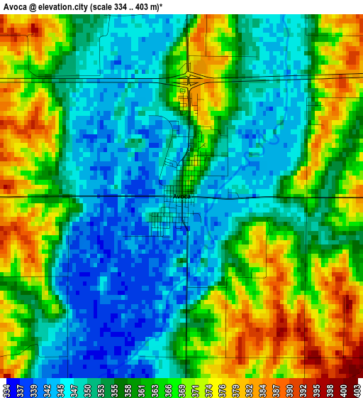
Below is the Elevation map of Avoca, which displays elevation range with different colors. Scale of the first map is from 334 to 403 m (1096 to 1322 ft) with average elevation of 359 meters (=1178 ft) [note 1]
These maps also provides idea of topography and contour of this city, they are displayed at different zoom levels. More info about maps, scale and edge coordinates you can find below images.
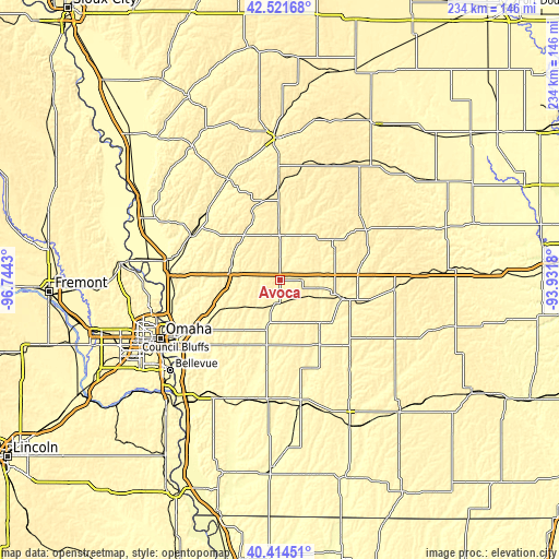
| \ | Map #1 | Topo.Map |
| Scale [m] | 334..403 m | × |
| Scale [ft] | 1096..1322 ft | × |
| Average | 359 m = 1178 ft | × |
| Width | 7.32 km = 4.5 mi | 234.3 km = 145.6 mi |
| Height | 7.32 km = 4.5 mi | 234.3 km = 145.6 mi |
| ↑Max Latitude | 41.509577° | 42.52168° |
| Latitude at center | 41.47666° | 41.47666° |
| ↓Min Latitude | 41.443727° | 40.41451° |
| ← Min Longitude | -95.381995° | -96.7443° |
| Longitude center | -95.33805° | -95.33805° |
| →Max Longitude | -95.294105° | -93.9318° |
Nearby cities:
Cities around Avoca sort by population:
• Omaha elevation 315 m
55.9 km,  244°
244°
• Council Bluffs 299 m
49.7 km, 241°
• Atlantic 372 m
28.2 km,  106°
106°
• Red Oak 320 m
52.8 km,  169°
169°
• Harlan 385 m
19.6 km,  3°
3°
• Carter Lake 296 m
52.6 km,  246°
246°
• Missouri Valley 311 m
46.6 km,  280°
280°
• Audubon 397 m
43.1 km,  51°
51°
• Oakland 342 m
19.3 km,  194°
194°
• Manning 409 m
53.2 km,  25°
25°
• Logan 334 m
41.8 km,  296°
296°
• Woodbine 333 m
42 km,  313°
313°
Multilingual:
 En español:
Avoca elevación 360 m.
 En France:
Avoca élévation 360 m.


Sources and notes:
- [note 1] Map square and city borders are not equal. Map elevation data is calculated only from area inside that square.
- [src 1] Elevation data from geonames database provided with same terms of usage.
- [src 2] The elevation map of Avoca is generated using elevation data from NASA's 3 arcsec (90m) resolution SRTM data.
- [src 3] Base (background) map © OpenStreetMap contributors tiles are generated by Geofabrik and OpenTopoMap.
Copyright & License:
This Avoca Elevation Map is licensed under CC BY-SA. You may reuse any part from this page, if you give a proper credit by linking to this URL:
 More info on terms of use page.