Guthrie Center elevation
Guthrie Center (Iowa, Guthrie County), United States elevation is 339 meters and Guthrie Center elevation in feet is 1112 ft above sea level [src 1]. Guthrie Center is a seat of a second-order administrative division (feature code) with elevation that is 60 meters (197 ft) bigger than average city elevation in United States.
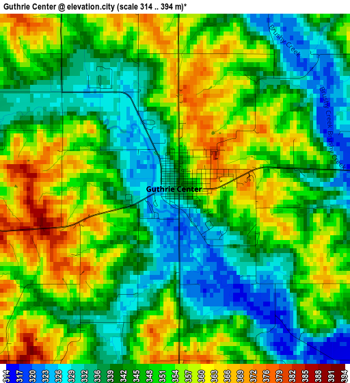
Below is the Elevation map of Guthrie Center, which displays elevation range with different colors. Scale of the first map is from 314 to 394 m (1030 to 1293 ft) with average elevation of 347.3 meters (=1139 ft) [note 1]
These maps also provides idea of topography and contour of this city, they are displayed at different zoom levels. More info about maps, scale and edge coordinates you can find below images.
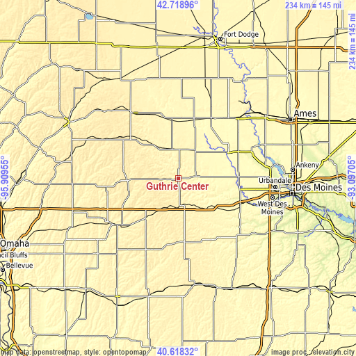
| \ | Map #1 | Topo.Map |
| Scale [m] | 314..394 m | × |
| Scale [ft] | 1030..1293 ft | × |
| Average | 347.3 m = 1139 ft | × |
| Width | 7.3 km = 4.5 mi | 233.6 km = 145.2 mi |
| Height | 7.3 km = 4.5 mi | 233.6 km = 145.2 mi |
| ↑Max Latitude | 41.710025° | 42.71896° |
| Latitude at center | 41.67721° | 41.67721° |
| ↓Min Latitude | 41.644379° | 40.61832° |
| ← Min Longitude | -94.547245° | -95.90955° |
| Longitude center | -94.5033° | -94.5033° |
| →Max Longitude | -94.459355° | -93.09705° |
Nearby cities:
Cities around Guthrie Center sort by population:
• Perry elevation 290 m
37.4 km,  61°
61°
• Adel 271 m
41 km,  99°
99°
• Jefferson 323 m
39 km,  15°
15°
• Audubon 397 m
35.9 km,  277°
277°
• Greenfield 417 m
41.5 km,  175°
175°
• Dallas Center 324 m
45 km,  88°
88°
• Stuart 367 m
24.7 km,  141°
141°
• Earlham 337 m
37.7 km,  123°
123°
• Lake Panorama 325 m
10.1 km,  68°
68°
• Coon Rapids 354 m
25.9 km,  326°
326°
• De Soto 287 m
44.1 km,  111°
111°
• Panora 325 m
11.8 km,  82°
82°
Multilingual:
 En español:
Guthrie Center elevación 339 m.
 En France:
Guthrie Center élévation 339 m.
 Auf Deutsch:
Guthrie Center höhe über dem Meeresspiegel ist 339 m.

Sources and notes:
- [note 1] Map square and city borders are not equal. Map elevation data is calculated only from area inside that square.
- [src 1] Elevation data from geonames database provided with same terms of usage.
- [src 2] The elevation map of Guthrie Center is generated using elevation data from NASA's 3 arcsec (90m) resolution SRTM data.
- [src 3] Base (background) map © OpenStreetMap contributors tiles are generated by Geofabrik and OpenTopoMap.
Copyright & License:
This Guthrie Center Elevation Map is licensed under CC BY-SA. You may reuse any part from this page, if you give a proper credit by linking to this URL:
 More info on terms of use page.