Earlham elevation
Earlham (Iowa, Madison County), United States elevation is 337 meters and Earlham elevation in feet is 1106 ft above sea level [src 1]. Earlham is a populated place (feature code) with elevation that is 58 meters (190 ft) bigger than average city elevation in United States.
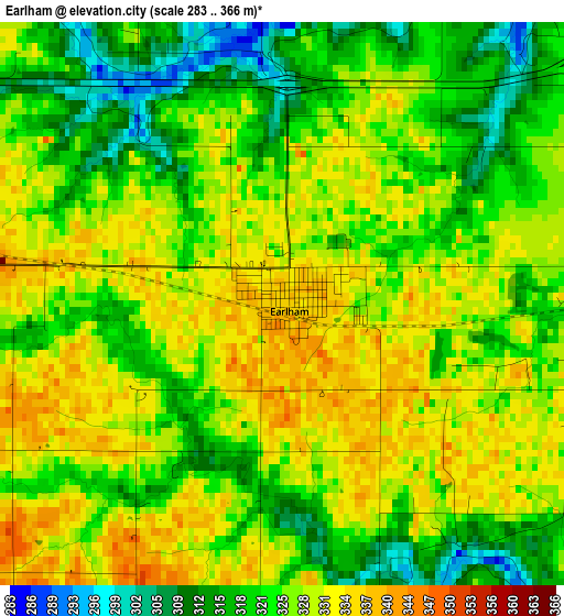
Below is the Elevation map of Earlham, which displays elevation range with different colors. Scale of the first map is from 283 to 366 m (928 to 1201 ft) with average elevation of 325.1 meters (=1067 ft) [note 1]
These maps also provides idea of topography and contour of this city, they are displayed at different zoom levels. More info about maps, scale and edge coordinates you can find below images.
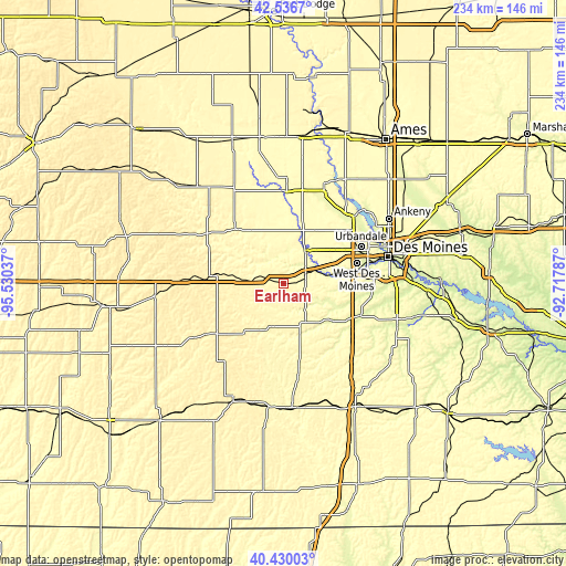
| \ | Map #1 | Topo.Map |
| Scale [m] | 283..366 m | × |
| Scale [ft] | 928..1201 ft | × |
| Average | 325.1 m = 1067 ft | × |
| Width | 7.32 km = 4.5 mi | 234.2 km = 145.5 mi |
| Height | 7.32 km = 4.5 mi | 234.2 km = 145.5 mi |
| ↑Max Latitude | 41.524839° | 42.5367° |
| Latitude at center | 41.49193° | 41.49193° |
| ↓Min Latitude | 41.459004° | 40.43003° |
| ← Min Longitude | -94.168065° | -95.53037° |
| Longitude center | -94.12412° | -94.12412° |
| →Max Longitude | -94.080175° | -92.71787° |
Nearby cities:
Cities around Earlham sort by population:
• Waukee elevation 313 m
23.9 km,  56°
56°
• Grimes 289 m
35.3 km,  51°
51°
• Winterset 334 m
20.1 km,  152°
152°
• Adel 271 m
16.3 km,  33°
33°
• Greenfield 417 m
35 km,  233°
233°
• Dallas Center 324 m
25.3 km, 32°
• Stuart 367 m
16.2 km,  274°
274°
• Lake Panorama 325 m
32.9 km,  317°
317°
• Buffalo (historical) 278 m
22.5 km, 153°
• Van Meter 264 m
14.8 km,  72°
72°
• De Soto 287 m
10.5 km, 65°
• Panora 325 m
29.8 km, 318°
Multilingual:
 En español:
Earlham elevación 337 m.
 En France:
Earlham élévation 337 m.


Sources and notes:
- [note 1] Map square and city borders are not equal. Map elevation data is calculated only from area inside that square.
- [src 1] Elevation data from geonames database provided with same terms of usage.
- [src 2] The elevation map of Earlham is generated using elevation data from NASA's 3 arcsec (90m) resolution SRTM data.
- [src 3] Base (background) map © OpenStreetMap contributors tiles are generated by Geofabrik and OpenTopoMap.
Copyright & License:
This Earlham Elevation Map is licensed under CC BY-SA. You may reuse any part from this page, if you give a proper credit by linking to this URL:
 More info on terms of use page.