Coon Rapids elevation
Coon Rapids (Iowa, Carroll County), United States elevation is 354 meters and Coon Rapids elevation in feet is 1161 ft above sea level [src 1]. Coon Rapids is a populated place (feature code) with elevation that is 75 meters (246 ft) bigger than average city elevation in United States.
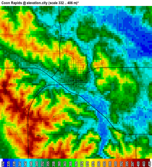
Below is the Elevation map of Coon Rapids, which displays elevation range with different colors. Scale of the first map is from 332 to 406 m (1089 to 1332 ft) with average elevation of 362.2 meters (=1188 ft) [note 1]
These maps also provides idea of topography and contour of this city, they are displayed at different zoom levels. More info about maps, scale and edge coordinates you can find below images.
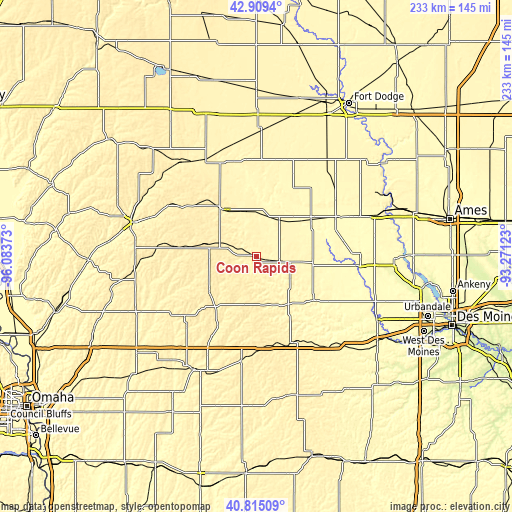
| \ | Map #1 | Topo.Map |
| Scale [m] | 332..406 m | × |
| Scale [ft] | 1089..1332 ft | × |
| Average | 362.2 m = 1188 ft | × |
| Width | 7.28 km = 4.5 mi | 232.9 km = 144.7 mi |
| Height | 7.28 km = 4.5 mi | 232.9 km = 144.7 mi |
| ↑Max Latitude | 41.903536° | 42.9094° |
| Latitude at center | 41.87082° | 41.87082° |
| ↓Min Latitude | 41.838088° | 40.81509° |
| ← Min Longitude | -94.721425° | -96.08373° |
| Longitude center | -94.67748° | -94.67748° |
| →Max Longitude | -94.633535° | -93.27123° |
Nearby cities:
Cities around Coon Rapids sort by population:
• Carroll elevation 385 m
26.7 km,  324°
324°
• Perry 290 m
47.4 km,  94°
94°
• Jefferson 323 m
29.6 km,  57°
57°
• Ogden 335 m
56.9 km,  70°
70°
• Audubon 397 m
27.1 km,  231°
231°
• Lake City 374 m
44.3 km,  353°
353°
• Stuart 367 m
50.6 km,  143°
143°
• Guthrie Center 339 m
25.9 km,  146°
146°
• Manning 409 m
32.4 km,  277°
277°
• Lake Panorama 325 m
29.7 km,  126°
126°
• Glidden 372 m
21.1 km, 348°
• Panora 325 m
32.8 km, 127°
Multilingual:
 En español:
Coon Rapids elevación 354 m.
 En France:
Coon Rapids élévation 354 m.
 Auf Deutsch:
Coon Rapids höhe über dem Meeresspiegel ist 354 m.

Sources and notes:
- [note 1] Map square and city borders are not equal. Map elevation data is calculated only from area inside that square.
- [src 1] Elevation data from geonames database provided with same terms of usage.
- [src 2] The elevation map of Coon Rapids is generated using elevation data from NASA's 3 arcsec (90m) resolution SRTM data.
- [src 3] Base (background) map © OpenStreetMap contributors tiles are generated by Geofabrik and OpenTopoMap.
Copyright & License:
This Coon Rapids Elevation Map is licensed under CC BY-SA. You may reuse any part from this page, if you give a proper credit by linking to this URL:
 More info on terms of use page.