Albia elevation
Albia (Iowa, Monroe County), United States elevation is 292 meters and Albia elevation in feet is 958 ft above sea level [src 1]. Albia is a seat of a second-order administrative division (feature code) with elevation that is 13 meters (43 ft) bigger than average city elevation in United States.
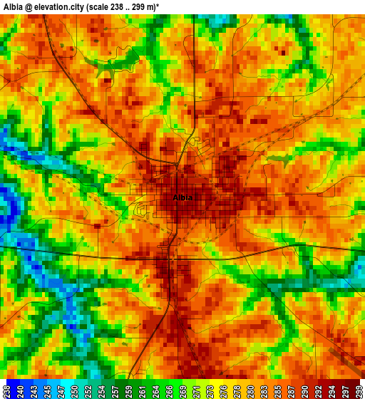
Below is the Elevation map of Albia, which displays elevation range with different colors. Scale of the first map is from 238 to 299 m (781 to 981 ft) with average elevation of 277 meters (=909 ft) [note 1]
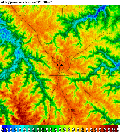
These maps also provides idea of topography and contour of this city, they are displayed at different zoom levels. More info about maps, scale and edge coordinates you can find below images.
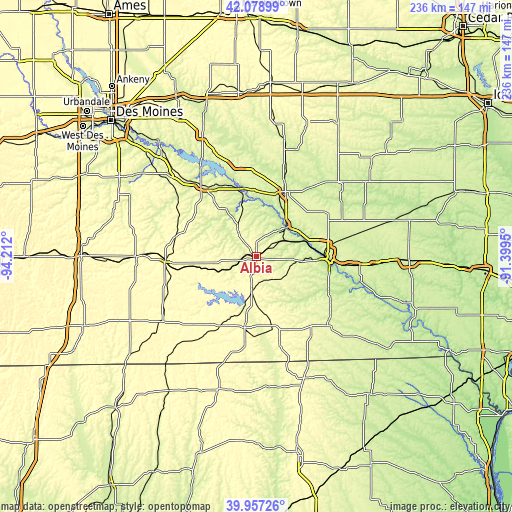
| \ | Map #1 | Map #2 | Topo.Map |
| Scale [m] | 238..299 m | 222..310 m | × |
| Scale [ft] | 781..981 ft | 728..1017 ft | × |
| Average | 277 m = 909 ft | 272.6 m = 894 ft | × |
| Width | 7.37 km = 4.6 mi | 14.74 km = 9.2 mi | 235.9 km = 146.6 mi |
| Height | 7.37 km = 4.6 mi | 14.74 km = 9.2 mi | 235.9 km = 146.6 mi |
| ↑Max Latitude | 41.059814° | 41.092942° | 42.07899° |
| Latitude at center | 41.02667° | 41.02667° | 41.02667° |
| ↓Min Latitude | 40.993509° | 40.960332° | 39.95726° |
| ← Min Longitude | -92.849695° | -92.893641° | -94.212° |
| Longitude center | -92.80575° | -92.80575° | -92.80575° |
| →Max Longitude | -92.761805° | -92.717859° | -91.3995° |
Nearby cities:
Cities around Albia sort by population:
• Ottumwa elevation 205 m
33.1 km,  91°
91°
• Oskaloosa 256 m
32.9 km,  24°
24°
• Pella 273 m
43.4 km,  347°
347°
• Knoxville 276 m
41.4 km,  322°
322°
• Centerville 311 m
33 km,  190°
190°
• Chariton 315 m
42 km,  268°
268°
• Bloomfield 265 m
44.9 km,  132°
132°
• Pleasantville 274 m
55.7 km, 315°
• Corydon 334 m
52.5 km,  235°
235°
• New Sharon 269 m
51 km,  14°
14°
• Melcher-Dallas 286 m
42.6 km,  301°
301°
• Eddyville 204 m
20.2 km,  44°
44°
Multilingual:
 En español:
Albia elevación 292 m.
 En France:
Albia élévation 292 m.


Sources and notes:
- [note 1] Map square and city borders are not equal. Map elevation data is calculated only from area inside that square.
- [src 1] Elevation data from geonames database provided with same terms of usage.
- [src 2] The elevation map of Albia is generated using elevation data from NASA's 3 arcsec (90m) resolution SRTM data.
- [src 3] Base (background) map © OpenStreetMap contributors tiles are generated by Geofabrik and OpenTopoMap.
Copyright & License:
This Albia Elevation Map is licensed under CC BY-SA. You may reuse any part from this page, if you give a proper credit by linking to this URL:
 More info on terms of use page.