Knoxville elevation
Knoxville (Iowa, Marion County), United States elevation is 276 meters and Knoxville elevation in feet is 906 ft above sea level [src 1]. Knoxville is a seat of a second-order administrative division (feature code) with elevation that is 3 meters (10 ft) smaller than average city elevation in United States.
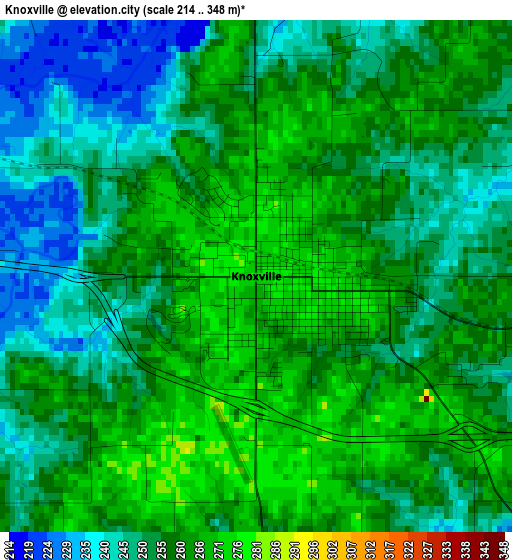
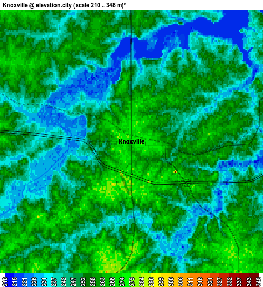
Below is the Elevation map of Knoxville, which displays elevation range with different colors. Scale of the first map is from 214 to 348 m (702 to 1142 ft) with average elevation of 256.4 meters (=841 ft) [note 1]
These maps also provides idea of topography and contour of this city, they are displayed at different zoom levels. More info about maps, scale and edge coordinates you can find below images.
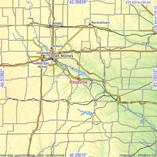
| \ | Map #1 | Map #2 | Topo.Map |
| Scale [m] | 214..348 m | 210..348 m | × |
| Scale [ft] | 702..1142 ft | 689..1142 ft | × |
| Average | 256.4 m = 841 ft | 250.5 m = 822 ft | × |
| Width | 7.34 km = 4.6 mi | 14.68 km = 9.1 mi | 234.9 km = 146 mi |
| Height | 7.34 km = 4.6 mi | 14.68 km = 9.1 mi | 234.9 km = 146 mi |
| ↑Max Latitude | 41.353826° | 41.386805° | 42.36839° |
| Latitude at center | 41.32083° | 41.32083° | 41.32083° |
| ↓Min Latitude | 41.287818° | 41.254789° | 40.25616° |
| ← Min Longitude | -93.153315° | -93.197261° | -94.51562° |
| Longitude center | -93.10937° | -93.10937° | -93.10937° |
| →Max Longitude | -93.065425° | -93.021479° | -91.70312° |
Nearby cities:
Cities around Knoxville sort by population:
• Indianola elevation 294 m
37.6 km,  276°
276°
• Oskaloosa 256 m
38.9 km,  94°
94°
• Pella 273 m
18.8 km,  58°
58°
• Chariton 315 m
37.9 km,  205°
205°
• Carlisle 255 m
37.6 km,  302°
302°
• Albia 292 m
41.4 km,  142°
142°
• Colfax 245 m
41.3 km,  344°
344°
• Monroe 280 m
22.4 km,  1°
1°
• Prairie City 279 m
32.7 km, 341°
• Pleasantville 274 m
15.2 km, 298°
• New Sharon 269 m
41.7 km,  66°
66°
• Melcher-Dallas 286 m
15.3 km,  225°
225°
Multilingual:
 En español:
Knoxville elevación 276 m.
 En France:
Knoxville élévation 276 m.
 Auf Deutsch:
Knoxville höhe über dem Meeresspiegel ist 276 m.

Sources and notes:
- [note 1] Map square and city borders are not equal. Map elevation data is calculated only from area inside that square.
- [src 1] Elevation data from geonames database provided with same terms of usage.
- [src 2] The elevation map of Knoxville is generated using elevation data from NASA's 3 arcsec (90m) resolution SRTM data.
- [src 3] Base (background) map © OpenStreetMap contributors tiles are generated by Geofabrik and OpenTopoMap.
Copyright & License:
This Knoxville Elevation Map is licensed under CC BY-SA. You may reuse any part from this page, if you give a proper credit by linking to this URL:
 More info on terms of use page.