Melcher-Dallas elevation
Melcher-Dallas (Iowa, Marion County), United States elevation is 286 meters and Melcher-Dallas elevation in feet is 938 ft above sea level [src 1]. Melcher-Dallas is a populated place (feature code) with elevation that is 7 meters (23 ft) bigger than average city elevation in United States.
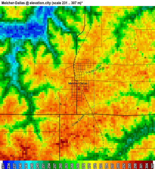
Below is the Elevation map of Melcher-Dallas, which displays elevation range with different colors. Scale of the first map is from 231 to 307 m (758 to 1007 ft) with average elevation of 273.6 meters (=898 ft) [note 1]
These maps also provides idea of topography and contour of this city, they are displayed at different zoom levels. More info about maps, scale and edge coordinates you can find below images.
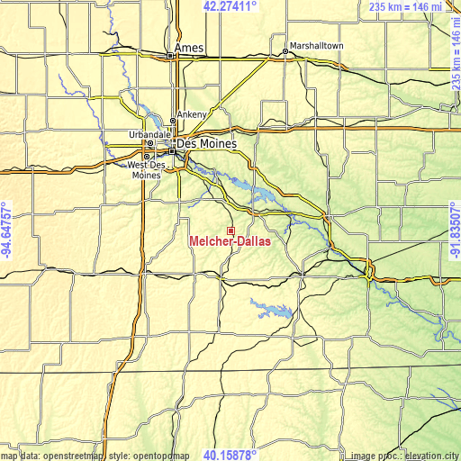
| \ | Map #1 | Topo.Map |
| Scale [m] | 231..307 m | × |
| Scale [ft] | 758..1007 ft | × |
| Average | 273.6 m = 898 ft | × |
| Width | 7.35 km = 4.6 mi | 235.2 km = 146.1 mi |
| Height | 7.35 km = 4.6 mi | 235.2 km = 146.1 mi |
| ↑Max Latitude | 41.258044° | 42.27411° |
| Latitude at center | 41.225° | 41.225° |
| ↓Min Latitude | 41.191939° | 40.15878° |
| ← Min Longitude | -93.285265° | -94.64757° |
| Longitude center | -93.24132° | -93.24132° |
| →Max Longitude | -93.197375° | -91.83507° |
Nearby cities:
Cities around Melcher-Dallas sort by population:
• Indianola elevation 294 m
30.3 km,  299°
299°
• Pella 273 m
33.9 km,  53°
53°
• Norwalk 289 m
45.9 km,  307°
307°
• Pleasant Hill 255 m
46.2 km,  329°
329°
• Knoxville 276 m
15.3 km, 45°
• Osceola 350 m
48.8 km,  244°
244°
• Chariton 315 m
24.1 km,  193°
193°
• Carlisle 255 m
37.1 km, 325°
• Albia 292 m
42.6 km,  121°
121°
• Monroe 280 m
35 km,  19°
19°
• Prairie City 279 m
41.6 km,  0°
0°
• Pleasantville 274 m
18 km,  352°
352°
Multilingual:
 En español:
Melcher-Dallas elevación 286 m.
 En France:
Melcher-Dallas élévation 286 m.
 Auf Deutsch:
Melcher-Dallas höhe über dem Meeresspiegel ist 286 m.

Sources and notes:
- [note 1] Map square and city borders are not equal. Map elevation data is calculated only from area inside that square.
- [src 1] Elevation data from geonames database provided with same terms of usage.
- [src 2] The elevation map of Melcher-Dallas is generated using elevation data from NASA's 3 arcsec (90m) resolution SRTM data.
- [src 3] Base (background) map © OpenStreetMap contributors tiles are generated by Geofabrik and OpenTopoMap.
Copyright & License:
This Melcher-Dallas Elevation Map is licensed under CC BY-SA. You may reuse any part from this page, if you give a proper credit by linking to this URL:
 More info on terms of use page.