Watertown elevation
Watertown (Tennessee, Wilson County), United States elevation is 198 meters and Watertown elevation in feet is 650 ft above sea level [src 1]. Watertown is a populated place (feature code) with elevation that is 81 meters (266 ft) smaller than average city elevation in United States.
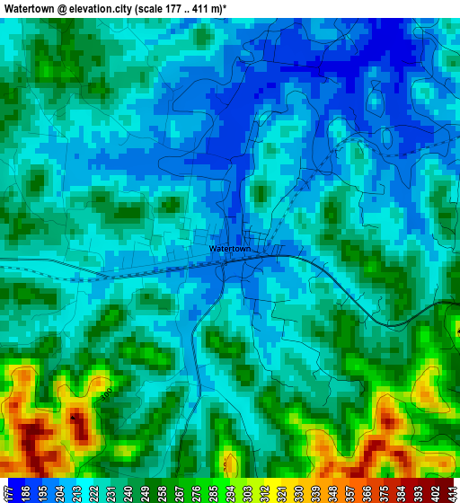
Below is the Elevation map of Watertown, which displays elevation range with different colors. Scale of the first map is from 177 to 411 m (581 to 1348 ft) with average elevation of 233.7 meters (=767 ft) [note 1]
These maps also provides idea of topography and contour of this city, they are displayed at different zoom levels. More info about maps, scale and edge coordinates you can find below images.
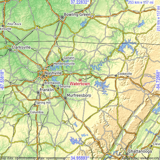
| \ | Map #1 | Topo.Map |
| Scale [m] | 177..411 m | × |
| Scale [ft] | 581..1348 ft | × |
| Average | 233.7 m = 767 ft | × |
| Width | 7.9 km = 4.9 mi | 252.7 km = 157 mi |
| Height | 7.9 km = 4.9 mi | 252.7 km = 157 mi |
| ↑Max Latitude | 36.135839° | 37.22832° |
| Latitude at center | 36.10034° | 36.10034° |
| ↓Min Latitude | 36.064825° | 34.95593° |
| ← Min Longitude | -86.175875° | -87.53818° |
| Longitude center | -86.13193° | -86.13193° |
| →Max Longitude | -86.087985° | -84.72568° |
Nearby cities:
Cities around Watertown sort by population:
• Murfreesboro elevation 191 m
36.6 km,  219°
219°
• Smyrna 167 m
37.1 km,  249°
249°
• Mount Juliet 168 m
36.4 km,  287°
287°
• Lebanon 161 m
18.6 km,  309°
309°
• Smithville 315 m
32.5 km,  118°
118°
• Lafayette 297 m
38.5 km,  75°
75°
• Woodbury 222 m
30.8 km,  169°
169°
• Hartsville 149 m
32.5 km,  354°
354°
• Carthage 163 m
23.4 km,  43°
43°
• Rural Hill 176 m
31.2 km,  273°
273°
• South Carthage 148 m
22.6 km,  45°
45°
• Gordonsville 166 m
19.9 km,  66°
66°
Multilingual:
 En español:
Watertown elevación 198 m.
 En France:
Watertown élévation 198 m.
 Auf Deutsch:
Watertown höhe über dem Meeresspiegel ist 198 m.

Sources and notes:
- [note 1] Map square and city borders are not equal. Map elevation data is calculated only from area inside that square.
- [src 1] Elevation data from geonames database provided with same terms of usage.
- [src 2] The elevation map of Watertown is generated using elevation data from NASA's 3 arcsec (90m) resolution SRTM data.
- [src 3] Base (background) map © OpenStreetMap contributors tiles are generated by Geofabrik and OpenTopoMap.
Copyright & License:
This Watertown Elevation Map is licensed under CC BY-SA. You may reuse any part from this page, if you give a proper credit by linking to this URL:
 More info on terms of use page.