Lafayette elevation
Lafayette (Tennessee, Putnam County), United States elevation is 297 meters and Lafayette elevation in feet is 974 ft above sea level [src 1]. Lafayette is a populated place (feature code) with elevation that is 18 meters (59 ft) bigger than average city elevation in United States.
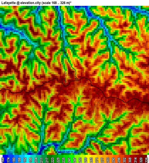
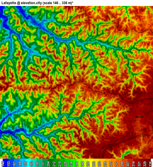
Below is the Elevation map of Lafayette, which displays elevation range with different colors. Scale of the first map is from 168 to 326 m (551 to 1070 ft) with average elevation of 267 meters (=876 ft) [note 1]
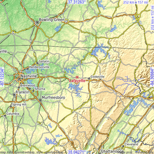
These maps also provides idea of topography and contour of this city, they are displayed at different zoom levels. More info about maps, scale and edge coordinates you can find below images.
| \ | Map #1 | Map #2 | Topo.Map |
| Scale [m] | 168..326 m | 146..336 m | × |
| Scale [ft] | 551..1070 ft | 479..1102 ft | × |
| Average | 267 m = 876 ft | 262.4 m = 861 ft | × |
| Width | 7.89 km = 4.9 mi | 15.77 km = 9.8 mi | 252.4 km = 156.8 mi |
| Height | 7.89 km = 4.9 mi | 15.77 km = 9.8 mi | 252.4 km = 156.8 mi |
| ↑Max Latitude | 36.22135° | 36.256795° | 37.31263° |
| Latitude at center | 36.18589° | 36.18589° | 36.18589° |
| ↓Min Latitude | 36.150413° | 36.114921° | 35.04271° |
| ← Min Longitude | -85.760035° | -85.803981° | -87.12234° |
| Longitude center | -85.71609° | -85.71609° | -85.71609° |
| →Max Longitude | -85.672145° | -85.628199° | -84.30984° |
Nearby cities:
Cities around Lafayette sort by population:
• Cookeville elevation 338 m
19.4 km,  97°
97°
• Sparta 279 m
36.7 km,  141°
141°
• Smithville 315 m
26.6 km,  199°
199°
• Algood 338 m
24 km,  87°
87°
• Monterey 574 m
40.4 km, 96°
• Carthage 163 m
22.4 km,  289°
289°
• Watertown 198 m
38.5 km,  255°
255°
• Baxter 311 m
7.4 km,  118°
118°
• South Carthage 148 m
22.1 km, 286°
• Gordonsville 166 m
19.2 km,  265°
265°
• Dodson Branch 296 m
21.7 km,  49°
49°
• Gainesboro 177 m
19.6 km,  15°
15°
Multilingual:
 En español:
Lafayette elevación 297 m.
 En France:
Lafayette élévation 297 m.
 Auf Deutsch:
Lafayette höhe über dem Meeresspiegel ist 297 m.

Sources and notes:
- [note 1] Map square and city borders are not equal. Map elevation data is calculated only from area inside that square.
- [src 1] Elevation data from geonames database provided with same terms of usage.
- [src 2] The elevation map of Lafayette is generated using elevation data from NASA's 3 arcsec (90m) resolution SRTM data.
- [src 3] Base (background) map © OpenStreetMap contributors tiles are generated by Geofabrik and OpenTopoMap.
Copyright & License:
This Lafayette Elevation Map is licensed under CC BY-SA. You may reuse any part from this page, if you give a proper credit by linking to this URL:
 More info on terms of use page.