Hartsville elevation
Hartsville (Tennessee, Trousdale County), United States elevation is 149 meters and Hartsville elevation in feet is 489 ft above sea level [src 1]. Hartsville is a seat of a second-order administrative division (feature code) with elevation that is 130 meters (427 ft) smaller than average city elevation in United States.
Below is the Elevation map of Hartsville, which displays elevation range with different colors. Scale of the first map is from 132 to 318 m (433 to 1043 ft) with average elevation of 172.8 meters (=567 ft) [note 1]
These maps also provides idea of topography and contour of this city, they are displayed at different zoom levels. More info about maps, scale and edge coordinates you can find below images.
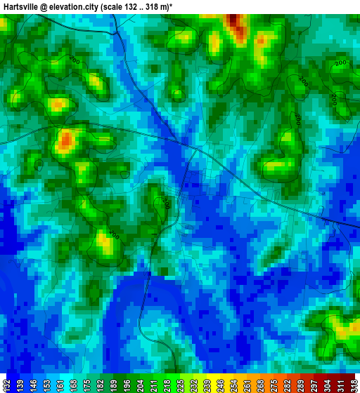
| \ | Map #1 | Topo.Map |
| Scale [m] | 132..318 m | × |
| Scale [ft] | 433..1043 ft | × |
| Average | 172.8 m = 567 ft | × |
| Width | 7.87 km = 4.9 mi | 251.7 km = 156.4 mi |
| Height | 7.87 km = 4.9 mi | 251.7 km = 156.4 mi |
| ↑Max Latitude | 36.426247° | 37.51462° |
| Latitude at center | 36.39088° | 36.39088° |
| ↓Min Latitude | 36.355496° | 35.25066° |
| ← Min Longitude | -86.211155° | -87.57346° |
| Longitude center | -86.16721° | -86.16721° |
| →Max Longitude | -86.123265° | -84.76096° |
Nearby cities:
Cities around Hartsville sort by population:
• Gallatin elevation 168 m
25 km,  269°
269°
• Mount Juliet 168 m
38 km,  236°
236°
• Lebanon 161 m
23.2 km,  208°
208°
• Portland 245 m
37.7 km,  304°
304°
• Green Hill 197 m
39 km, 241°
• Lafayette 292 m
19.2 km,  41°
41°
• Westmoreland 283 m
20.4 km,  339°
339°
• Carthage 163 m
24.7 km,  128°
128°
• Watertown 198 m
32.5 km,  174°
174°
• South Carthage 148 m
25.4 km, 130°
• Gordonsville 166 m
32.3 km,  138°
138°
• Red Boiling Springs 231 m
32.5 km,  60°
60°
Multilingual:
 En español:
Hartsville elevación 149 m.
 En France:
Hartsville élévation 149 m.
 Auf Deutsch:
Hartsville höhe über dem Meeresspiegel ist 149 m.

Sources and notes:
- [note 1] Map square and city borders are not equal. Map elevation data is calculated only from area inside that square.
- [src 1] Elevation data from geonames database provided with same terms of usage.
- [src 2] The elevation map of Hartsville is generated using elevation data from NASA's 3 arcsec (90m) resolution SRTM data.
- [src 3] Base (background) map © OpenStreetMap contributors tiles are generated by Geofabrik and OpenTopoMap.
Copyright & License:
This Hartsville Elevation Map is licensed under CC BY-SA. You may reuse any part from this page, if you give a proper credit by linking to this URL:
 More info on terms of use page.