Mooreland elevation
Mooreland (Oklahoma, Woodward County), United States elevation is 587 meters and Mooreland elevation in feet is 1926 ft above sea level [src 1]. Mooreland is a populated place (feature code) with elevation that is 308 meters (1010 ft) bigger than average city elevation in United States.
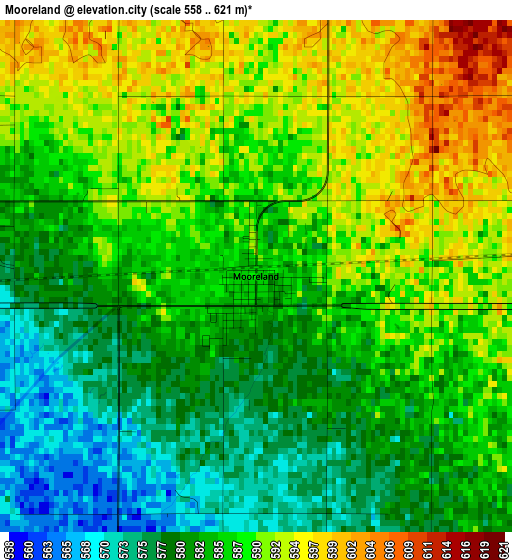
Below is the Elevation map of Mooreland, which displays elevation range with different colors. Scale of the first map is from 558 to 621 m (1831 to 2037 ft) with average elevation of 585.5 meters (=1921 ft) [note 1]
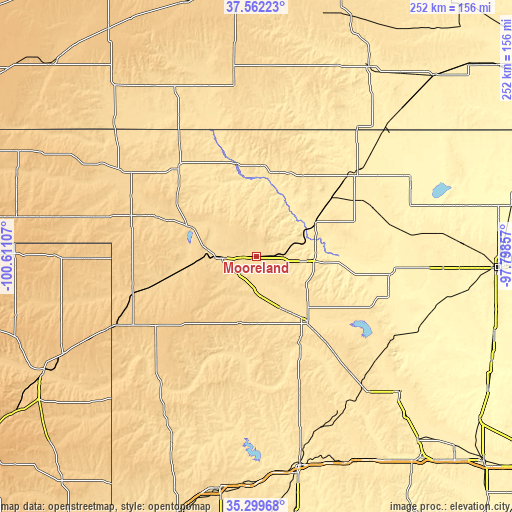
These maps also provides idea of topography and contour of this city, they are displayed at different zoom levels. More info about maps, scale and edge coordinates you can find below images.
| \ | Map #1 | Topo.Map |
| Scale [m] | 558..621 m | × |
| Scale [ft] | 1831..2037 ft | × |
| Average | 585.5 m = 1921 ft | × |
| Width | 7.86 km = 4.9 mi | 251.6 km = 156.3 mi |
| Height | 7.86 km = 4.9 mi | 251.6 km = 156.3 mi |
| ↑Max Latitude | 36.474545° | 37.56223° |
| Latitude at center | 36.4392° | 36.4392° |
| ↓Min Latitude | 36.403838° | 35.29968° |
| ← Min Longitude | -99.248765° | -100.61107° |
| Longitude center | -99.20482° | -99.20482° |
| →Max Longitude | -99.160875° | -97.79857° |
Nearby cities:
Cities around Mooreland sort by population:
• Woodward elevation 589 m
16.6 km,  267°
267°
• Alva 419 m
62.9 km,  49°
49°
• Fairview 404 m
67.6 km,  106°
106°
• Cherokee 368 m
83.4 km,  65°
65°
• Helena 436 m
84.4 km,  81°
81°
• Shattuck 691 m
63.4 km,  253°
253°
• Laverne 651 m
68.5 km,  296°
296°
• Buffalo 561 m
58.2 km,  319°
319°
• Thomas 540 m
87.5 km,  152°
152°
• Okeene 376 m
87.3 km, 114°
• Arnett 755 m
61.3 km,  236°
236°
• Taloga 527 m
49.5 km, 154°
Multilingual:
 En español:
Mooreland elevación 587 m.
 En France:
Mooreland élévation 587 m.
 Auf Deutsch:
Mooreland höhe über dem Meeresspiegel ist 587 m.

Sources and notes:
- [note 1] Map square and city borders are not equal. Map elevation data is calculated only from area inside that square.
- [src 1] Elevation data from geonames database provided with same terms of usage.
- [src 2] The elevation map of Mooreland is generated using elevation data from NASA's 3 arcsec (90m) resolution SRTM data.
- [src 3] Base (background) map © OpenStreetMap contributors tiles are generated by Geofabrik and OpenTopoMap.
Copyright & License:
This Mooreland Elevation Map is licensed under CC BY-SA. You may reuse any part from this page, if you give a proper credit by linking to this URL:
 More info on terms of use page.