Okeene elevation
Okeene (Oklahoma, Blaine County), United States elevation is 376 meters and Okeene elevation in feet is 1234 ft above sea level [src 1]. Okeene is a populated place (feature code) with elevation that is 97 meters (318 ft) bigger than average city elevation in United States.
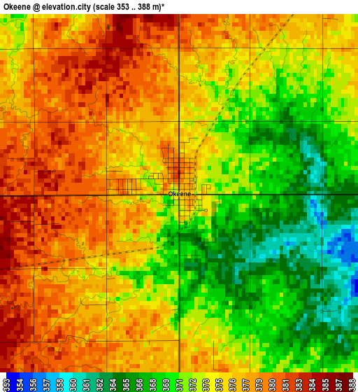
Below is the Elevation map of Okeene, which displays elevation range with different colors. Scale of the first map is from 353 to 388 m (1158 to 1273 ft) with average elevation of 374 meters (=1227 ft) [note 1]
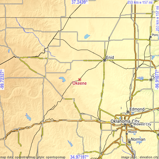
These maps also provides idea of topography and contour of this city, they are displayed at different zoom levels. More info about maps, scale and edge coordinates you can find below images.
| \ | Map #1 | Topo.Map |
| Scale [m] | 353..388 m | × |
| Scale [ft] | 1158..1273 ft | × |
| Average | 374 m = 1227 ft | × |
| Width | 7.89 km = 4.9 mi | 252.6 km = 157 mi |
| Height | 7.89 km = 4.9 mi | 252.6 km = 157 mi |
| ↑Max Latitude | 36.151642° | 37.2439° |
| Latitude at center | 36.11615° | 36.11615° |
| ↓Min Latitude | 36.080642° | 34.97197° |
| ← Min Longitude | -98.360965° | -99.72327° |
| Longitude center | -98.31702° | -98.31702° |
| →Max Longitude | -98.273075° | -96.91077° |
Nearby cities:
Cities around Okeene sort by population:
• Enid elevation 388 m
50.1 km,  51°
51°
• Kingfisher 327 m
44.8 km,  129°
129°
• Watonga 466 m
31.4 km,  195°
195°
• Fairview 404 m
22.4 km,  319°
319°
• Hennessey 360 m
37.6 km,  91°
91°
• Crescent 348 m
67.4 km,  105°
105°
• Helena 436 m
48 km,  5°
5°
• Waukomis 386 m
41.8 km,  64°
64°
• Okarche 381 m
53.1 km,  144°
144°
• Geary 474 m
53.9 km,  180°
180°
• Thomas 540 m
56.7 km,  223°
223°
• Taloga 527 m
58.8 km,  261°
261°
Multilingual:
 En español:
Okeene elevación 376 m.
 En France:
Okeene élévation 376 m.


Sources and notes:
- [note 1] Map square and city borders are not equal. Map elevation data is calculated only from area inside that square.
- [src 1] Elevation data from geonames database provided with same terms of usage.
- [src 2] The elevation map of Okeene is generated using elevation data from NASA's 3 arcsec (90m) resolution SRTM data.
- [src 3] Base (background) map © OpenStreetMap contributors tiles are generated by Geofabrik and OpenTopoMap.
Copyright & License:
This Okeene Elevation Map is licensed under CC BY-SA. You may reuse any part from this page, if you give a proper credit by linking to this URL:
 More info on terms of use page.