Crescent elevation
Crescent (Oklahoma, Logan County), United States elevation is 348 meters and Crescent elevation in feet is 1142 ft above sea level [src 1]. Crescent is a populated place (feature code) with elevation that is 69 meters (226 ft) bigger than average city elevation in United States.
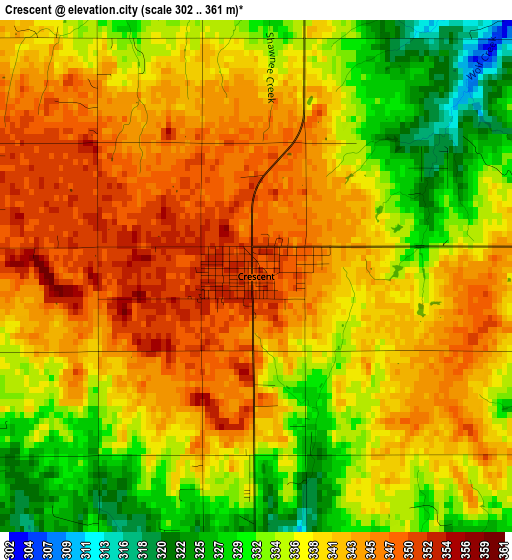
Below is the Elevation map of Crescent, which displays elevation range with different colors. Scale of the first map is from 302 to 361 m (991 to 1184 ft) with average elevation of 338.8 meters (=1112 ft) [note 1]
These maps also provides idea of topography and contour of this city, they are displayed at different zoom levels. More info about maps, scale and edge coordinates you can find below images.
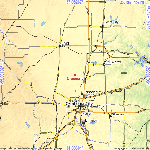
| \ | Map #1 | Topo.Map |
| Scale [m] | 302..361 m | × |
| Scale [ft] | 991..1184 ft | × |
| Average | 338.8 m = 1112 ft | × |
| Width | 7.91 km = 4.9 mi | 253.1 km = 157.3 mi |
| Height | 7.91 km = 4.9 mi | 253.1 km = 157.3 mi |
| ↑Max Latitude | 35.988106° | 37.08267° |
| Latitude at center | 35.95254° | 35.95254° |
| ↓Min Latitude | 35.916958° | 34.80601° |
| ← Min Longitude | -97.638715° | -99.00102° |
| Longitude center | -97.59477° | -97.59477° |
| →Max Longitude | -97.550825° | -96.18852° |
Nearby cities:
Cities around Crescent sort by population:
• Edmond elevation 372 m
34.9 km,  162°
162°
• Guthrie 307 m
17.3 km,  118°
118°
• Warr Acres 406 m
47.9 km,  182°
182°
• The Village 376 m
43.7 km,  174°
174°
• Piedmont 368 m
37.1 km,  201°
201°
• Perry 312 m
46.5 km,  36°
36°
• Kingfisher 327 m
32 km,  251°
251°
• Nichols Hills 375 m
44.9 km, 174°
• Hennessey 360 m
32.4 km,  302°
302°
• Langston 297 m
30.6 km,  91°
91°
• Waukomis 386 m
45.5 km,  323°
323°
• Okarche 381 m
42.6 km,  233°
233°
Multilingual:
 En español:
Crescent elevación 348 m.
 En France:
Crescent élévation 348 m.
 Auf Deutsch:
Crescent höhe über dem Meeresspiegel ist 348 m.

Sources and notes:
- [note 1] Map square and city borders are not equal. Map elevation data is calculated only from area inside that square.
- [src 1] Elevation data from geonames database provided with same terms of usage.
- [src 2] The elevation map of Crescent is generated using elevation data from NASA's 3 arcsec (90m) resolution SRTM data.
- [src 3] Base (background) map © OpenStreetMap contributors tiles are generated by Geofabrik and OpenTopoMap.
Copyright & License:
This Crescent Elevation Map is licensed under CC BY-SA. You may reuse any part from this page, if you give a proper credit by linking to this URL:
 More info on terms of use page.