The Village elevation
The Village (Oklahoma, Oklahoma County), United States elevation is 376 meters and The Village elevation in feet is 1234 ft above sea level [src 1]. The Village is a populated place (feature code) with elevation that is 97 meters (318 ft) bigger than average city elevation in United States.
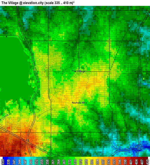
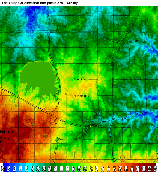
Below is the Elevation map of The Village, which displays elevation range with different colors. Scale of the first map is from 335 to 410 m (1099 to 1345 ft) with average elevation of 367.9 meters (=1207 ft) [note 1]
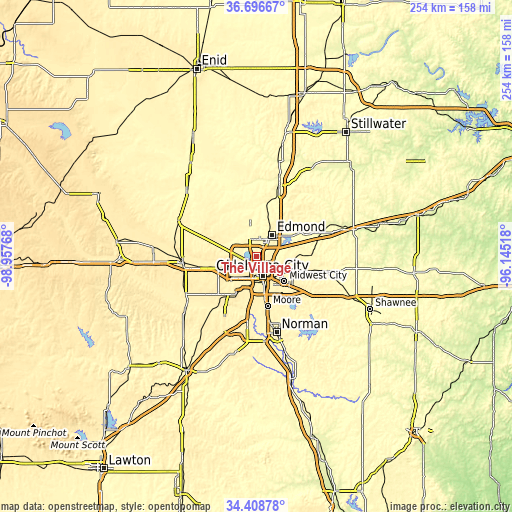
These maps also provides idea of topography and contour of this city, they are displayed at different zoom levels. More info about maps, scale and edge coordinates you can find below images.
| \ | Map #1 | Map #2 | Topo.Map |
| Scale [m] | 335..410 m | 325..415 m | × |
| Scale [ft] | 1099..1345 ft | 1066..1362 ft | × |
| Average | 367.9 m = 1207 ft | 364.5 m = 1196 ft | × |
| Width | 7.95 km = 4.9 mi | 15.9 km = 9.9 mi | 254.4 km = 158.1 mi |
| Height | 7.95 km = 4.9 mi | 15.9 km = 9.9 mi | 254.4 km = 158.1 mi |
| ↑Max Latitude | 35.596631° | 35.632357° | 36.69667° |
| Latitude at center | 35.56089° | 35.56089° | 35.56089° |
| ↓Min Latitude | 35.525133° | 35.489359° | 34.40878° |
| ← Min Longitude | -97.595375° | -97.639321° | -98.95768° |
| Longitude center | -97.55143° | -97.55143° | -97.55143° |
| →Max Longitude | -97.507485° | -97.463539° | -96.14518° |
Nearby cities:
Cities around The Village sort by population:
• Oklahoma City elevation 395 m
10.9 km,  163°
163°
• Edmond 372 m
12.2 km,  32°
32°
• Midwest City 386 m
18.7 km,  131°
131°
• Yukon 403 m
20 km,  252°
252°
• Del City 372 m
16.6 km,  142°
142°
• Bethany 404 m
8.7 km,  237°
237°
• Warr Acres 406 m
7.4 km, 235°
• Piedmont 368 m
19.8 km,  297°
297°
• Spencer 367 m
16.3 km,  105°
105°
• Nichols Hills 375 m
1.1 km,  168°
168°
• Nicoma Park 373 m
22.1 km, 110°
• Forest Park 376 m
11.4 km,  123°
123°
Multilingual:
 En español:
The Village elevación 376 m.
 En France:
The Village élévation 376 m.
 Auf Deutsch:
The Village höhe über dem Meeresspiegel ist 376 m.

Sources and notes:
- [note 1] Map square and city borders are not equal. Map elevation data is calculated only from area inside that square.
- [src 1] Elevation data from geonames database provided with same terms of usage.
- [src 2] The elevation map of The Village is generated using elevation data from NASA's 3 arcsec (90m) resolution SRTM data.
- [src 3] Base (background) map © OpenStreetMap contributors tiles are generated by Geofabrik and OpenTopoMap.
Copyright & License:
This The Village Elevation Map is licensed under CC BY-SA. You may reuse any part from this page, if you give a proper credit by linking to this URL:
 More info on terms of use page.