Perry elevation
Perry (Oklahoma, Noble County), United States elevation is 312 meters and Perry elevation in feet is 1024 ft above sea level [src 1]. Perry is a seat of a second-order administrative division (feature code) with elevation that is 33 meters (108 ft) bigger than average city elevation in United States.
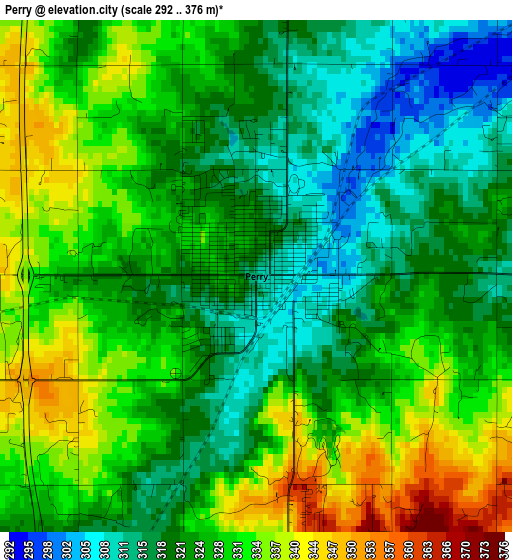
Below is the Elevation map of Perry, which displays elevation range with different colors. Scale of the first map is from 292 to 376 m (958 to 1234 ft) with average elevation of 325.5 meters (=1068 ft) [note 1]
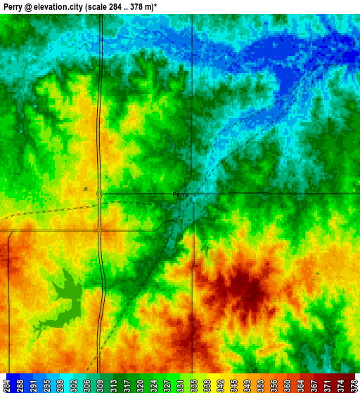
These maps also provides idea of topography and contour of this city, they are displayed at different zoom levels. More info about maps, scale and edge coordinates you can find below images.
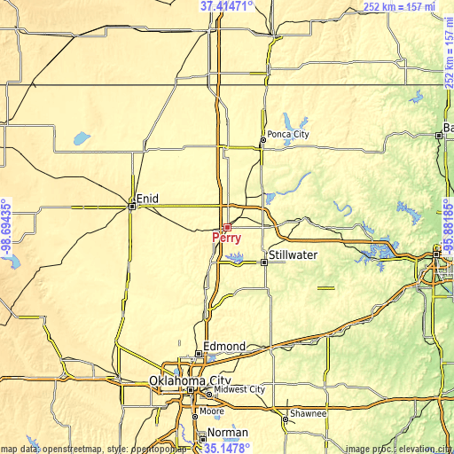
| \ | Map #1 | Map #2 | Topo.Map |
| Scale [m] | 292..376 m | 284..378 m | × |
| Scale [ft] | 958..1234 ft | 932..1240 ft | × |
| Average | 325.5 m = 1068 ft | 325.5 m = 1068 ft | × |
| Width | 7.88 km = 4.9 mi | 15.75 km = 9.8 mi | 252.1 km = 156.6 mi |
| Height | 7.88 km = 4.9 mi | 15.75 km = 9.8 mi | 252.1 km = 156.6 mi |
| ↑Max Latitude | 36.324904° | 36.360301° | 37.41471° |
| Latitude at center | 36.28949° | 36.28949° | 36.28949° |
| ↓Min Latitude | 36.25406° | 36.218615° | 35.1478° |
| ← Min Longitude | -97.332045° | -97.375991° | -98.69435° |
| Longitude center | -97.2881° | -97.2881° | -97.2881° |
| →Max Longitude | -97.244155° | -97.200209° | -95.88185° |
Nearby cities:
Cities around Perry sort by population:
• Enid elevation 388 m
54.2 km,  282°
282°
• Stillwater 277 m
28.3 km,  133°
133°
• Ponca City 315 m
49.8 km,  21°
21°
• Guthrie 307 m
47.3 km,  195°
195°
• Tonkawa 306 m
43.3 km,  357°
357°
• Perkins 278 m
41.9 km,  146°
146°
• Pawnee 270 m
43.7 km,  82°
82°
• Langston 297 m
38.4 km,  175°
175°
• Crescent 348 m
46.5 km,  216°
216°
• McCord 328 m
48.6 km,  27°
27°
• Waukomis 386 m
54.7 km,  268°
268°
• Yale 250 m
56.3 km,  110°
110°
Multilingual:
 En español:
Perry elevación 312 m.
 En France:
Perry élévation 312 m.


Sources and notes:
- [note 1] Map square and city borders are not equal. Map elevation data is calculated only from area inside that square.
- [src 1] Elevation data from geonames database provided with same terms of usage.
- [src 2] The elevation map of Perry is generated using elevation data from NASA's 3 arcsec (90m) resolution SRTM data.
- [src 3] Base (background) map © OpenStreetMap contributors tiles are generated by Geofabrik and OpenTopoMap.
Copyright & License:
This Perry Elevation Map is licensed under CC BY-SA. You may reuse any part from this page, if you give a proper credit by linking to this URL:
 More info on terms of use page.