Geary elevation
Geary (Oklahoma, Blaine County), United States elevation is 474 meters and Geary elevation in feet is 1555 ft above sea level [src 1]. Geary is a populated place (feature code) with elevation that is 195 meters (640 ft) bigger than average city elevation in United States.
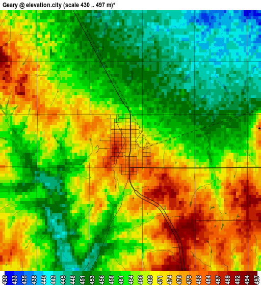
Below is the Elevation map of Geary, which displays elevation range with different colors. Scale of the first map is from 430 to 497 m (1411 to 1631 ft) with average elevation of 463.9 meters (=1522 ft) [note 1]
These maps also provides idea of topography and contour of this city, they are displayed at different zoom levels. More info about maps, scale and edge coordinates you can find below images.
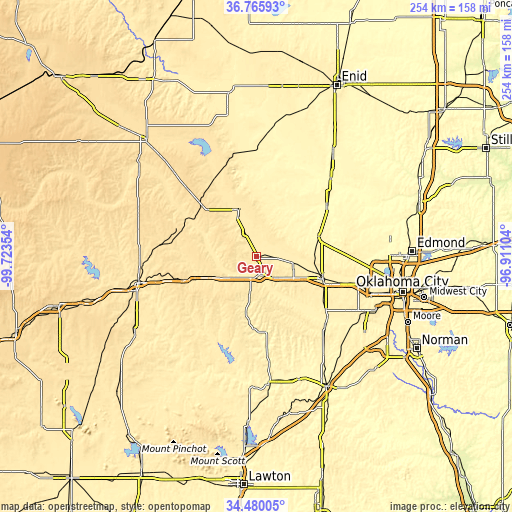
| \ | Map #1 | Topo.Map |
| Scale [m] | 430..497 m | × |
| Scale [ft] | 1411..1631 ft | × |
| Average | 463.9 m = 1522 ft | × |
| Width | 7.94 km = 4.9 mi | 254.2 km = 158 mi |
| Height | 7.94 km = 4.9 mi | 254.2 km = 158 mi |
| ↑Max Latitude | 35.66687° | 36.76593° |
| Latitude at center | 35.63116° | 35.63116° |
| ↓Min Latitude | 35.595434° | 34.48005° |
| ← Min Longitude | -98.361235° | -99.72354° |
| Longitude center | -98.31729° | -98.31729° |
| →Max Longitude | -98.273345° | -96.91104° |
Nearby cities:
Cities around Geary sort by population:
• Yukon elevation 403 m
52 km,  105°
105°
• El Reno 420 m
34.6 km, 108°
• Weatherford 508 m
37.2 km,  251°
251°
• Piedmont 368 m
51.6 km,  88°
88°
• Kingfisher 327 m
43.2 km,  53°
53°
• Hinton 516 m
18.1 km,  191°
191°
• Watonga 466 m
25.3 km,  339°
339°
• Union City 410 m
43.2 km,  128°
128°
• Minco 399 m
48.9 km,  136°
136°
• Okarche 381 m
32.5 km,  71°
71°
• Thomas 540 m
40.8 km,  287°
287°
• Okeene 376 m
53.9 km,  0°
0°
Multilingual:
 En español:
Geary elevación 474 m.
 En France:
Geary élévation 474 m.


Sources and notes:
- [note 1] Map square and city borders are not equal. Map elevation data is calculated only from area inside that square.
- [src 1] Elevation data from geonames database provided with same terms of usage.
- [src 2] The elevation map of Geary is generated using elevation data from NASA's 3 arcsec (90m) resolution SRTM data.
- [src 3] Base (background) map © OpenStreetMap contributors tiles are generated by Geofabrik and OpenTopoMap.
Copyright & License:
This Geary Elevation Map is licensed under CC BY-SA. You may reuse any part from this page, if you give a proper credit by linking to this URL:
 More info on terms of use page.