Weatherford elevation
Weatherford (Oklahoma, Custer County), United States elevation is 508 meters and Weatherford elevation in feet is 1667 ft above sea level [src 1]. Weatherford is a populated place (feature code) with elevation that is 229 meters (751 ft) bigger than average city elevation in United States.
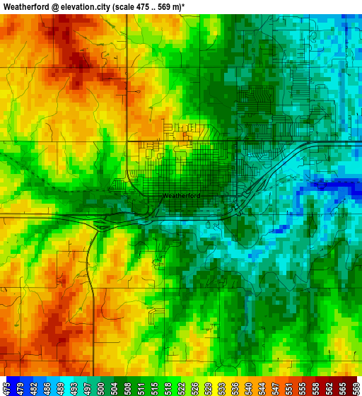
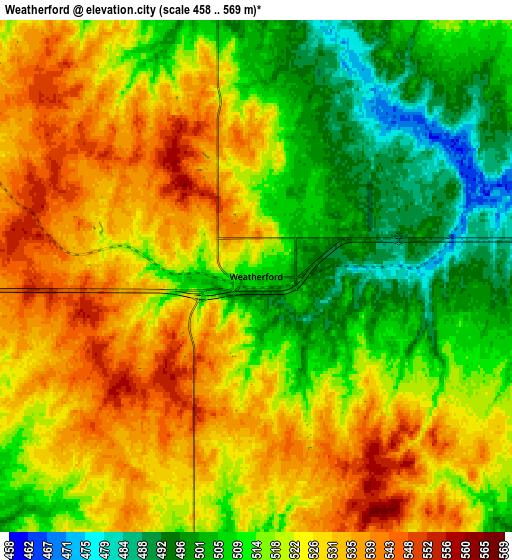
Below is the Elevation map of Weatherford, which displays elevation range with different colors. Scale of the first map is from 475 to 569 m (1558 to 1867 ft) with average elevation of 518.2 meters (=1700 ft) [note 1]
These maps also provides idea of topography and contour of this city, they are displayed at different zoom levels. More info about maps, scale and edge coordinates you can find below images.
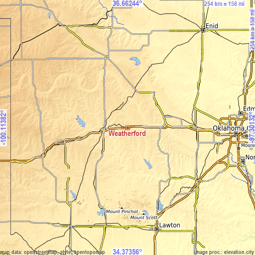
| \ | Map #1 | Map #2 | Topo.Map |
| Scale [m] | 475..569 m | 458..569 m | × |
| Scale [ft] | 1558..1867 ft | 1503..1867 ft | × |
| Average | 518.2 m = 1700 ft | 519.7 m = 1705 ft | × |
| Width | 7.95 km = 4.9 mi | 15.91 km = 9.9 mi | 254.5 km = 158.1 mi |
| Height | 7.95 km = 4.9 mi | 15.91 km = 9.9 mi | 254.5 km = 158.1 mi |
| ↑Max Latitude | 35.561917° | 35.597658° | 36.66244° |
| Latitude at center | 35.52616° | 35.52616° | 35.52616° |
| ↓Min Latitude | 35.490387° | 35.454598° | 34.37356° |
| ← Min Longitude | -98.751515° | -98.795461° | -100.11382° |
| Longitude center | -98.70757° | -98.70757° | -98.70757° |
| →Max Longitude | -98.663625° | -98.619679° | -97.30132° |
Nearby cities:
Cities around Weatherford sort by population:
• Elk City elevation 590 m
64.4 km,  258°
258°
• Clinton 482 m
23.5 km,  267°
267°
• Hobart 477 m
65.4 km,  212°
212°
• Hinton 516 m
32.4 km,  100°
100°
• Watonga 466 m
44.3 km,  36°
36°
• Cordell 481 m
36.5 km,  224°
224°
• Burns Flat 582 m
46.3 km,  244°
244°
• Carnegie 408 m
47.9 km,  168°
168°
• Geary 474 m
37.2 km,  71°
71°
• Thomas 540 m
24.5 km,  351°
351°
• Arapaho 509 m
23.9 km,  283°
283°
• Taloga 527 m
61.5 km,  337°
337°
Multilingual:
 En español:
Weatherford elevación 508 m.
 En France:
Weatherford élévation 508 m.
 Auf Deutsch:
Weatherford höhe über dem Meeresspiegel ist 508 m.

Sources and notes:
- [note 1] Map square and city borders are not equal. Map elevation data is calculated only from area inside that square.
- [src 1] Elevation data from geonames database provided with same terms of usage.
- [src 2] The elevation map of Weatherford is generated using elevation data from NASA's 3 arcsec (90m) resolution SRTM data.
- [src 3] Base (background) map © OpenStreetMap contributors tiles are generated by Geofabrik and OpenTopoMap.
Copyright & License:
This Weatherford Elevation Map is licensed under CC BY-SA. You may reuse any part from this page, if you give a proper credit by linking to this URL:
 More info on terms of use page.