Carnegie elevation
Carnegie (Oklahoma, Caddo County), United States elevation is 408 meters and Carnegie elevation in feet is 1339 ft above sea level [src 1]. Carnegie is a populated place (feature code) with elevation that is 129 meters (423 ft) bigger than average city elevation in United States.
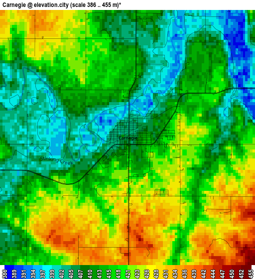
Below is the Elevation map of Carnegie, which displays elevation range with different colors. Scale of the first map is from 386 to 455 m (1266 to 1493 ft) with average elevation of 415.3 meters (=1363 ft) [note 1]
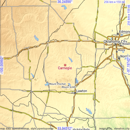
These maps also provides idea of topography and contour of this city, they are displayed at different zoom levels. More info about maps, scale and edge coordinates you can find below images.
| \ | Map #1 | Topo.Map |
| Scale [m] | 386..455 m | × |
| Scale [ft] | 1266..1493 ft | × |
| Average | 415.3 m = 1363 ft | × |
| Width | 7.99 km = 5 mi | 255.8 km = 158.9 mi |
| Height | 7.99 km = 5 mi | 255.8 km = 158.9 mi |
| ↑Max Latitude | 35.139614° | 36.24598° |
| Latitude at center | 35.10367° | 35.10367° |
| ↓Min Latitude | 35.06771° | 33.94512° |
| ← Min Longitude | -98.647615° | -100.00992° |
| Longitude center | -98.60367° | -98.60367° |
| →Max Longitude | -98.559725° | -97.19742° |
Nearby cities:
Cities around Carnegie sort by population:
• Weatherford elevation 508 m
47.9 km,  348°
348°
• Clinton 482 m
56.5 km,  324°
324°
• Anadarko 365 m
32.9 km,  96°
96°
• Hobart 477 m
45.3 km,  259°
259°
• Hinton 516 m
46.7 km,  28°
28°
• Elgin 398 m
45.8 km,  141°
141°
• Cache 392 m
52.8 km,  182°
182°
• Cordell 481 m
40.7 km,  300°
300°
• Burns Flat 582 m
58.2 km, 297°
• Apache 396 m
31.8 km, 137°
• Fletcher 422 m
45.2 km,  133°
133°
• Cyril 418 m
43.3 km,  122°
122°
Multilingual:
 En español:
Carnegie elevación 408 m.
 En France:
Carnegie élévation 408 m.
 Auf Deutsch:
Carnegie höhe über dem Meeresspiegel ist 408 m.

Sources and notes:
- [note 1] Map square and city borders are not equal. Map elevation data is calculated only from area inside that square.
- [src 1] Elevation data from geonames database provided with same terms of usage.
- [src 2] The elevation map of Carnegie is generated using elevation data from NASA's 3 arcsec (90m) resolution SRTM data.
- [src 3] Base (background) map © OpenStreetMap contributors tiles are generated by Geofabrik and OpenTopoMap.
Copyright & License:
This Carnegie Elevation Map is licensed under CC BY-SA. You may reuse any part from this page, if you give a proper credit by linking to this URL:
 More info on terms of use page.