Minco elevation
Minco (Oklahoma, Grady County), United States elevation is 399 meters and Minco elevation in feet is 1309 ft above sea level [src 1]. Minco is a populated place (feature code) with elevation that is 120 meters (394 ft) bigger than average city elevation in United States.
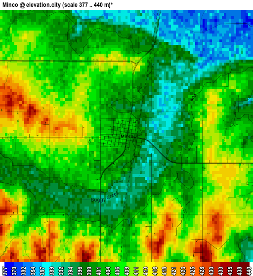
Below is the Elevation map of Minco, which displays elevation range with different colors. Scale of the first map is from 377 to 440 m (1237 to 1444 ft) with average elevation of 404.4 meters (=1327 ft) [note 1]
These maps also provides idea of topography and contour of this city, they are displayed at different zoom levels. More info about maps, scale and edge coordinates you can find below images.
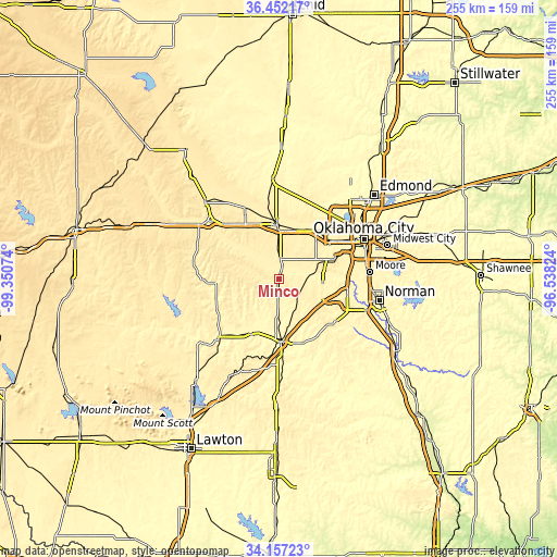
| \ | Map #1 | Topo.Map |
| Scale [m] | 377..440 m | × |
| Scale [ft] | 1237..1444 ft | × |
| Average | 404.4 m = 1327 ft | × |
| Width | 7.97 km = 5 mi | 255.2 km = 158.6 mi |
| Height | 7.97 km = 5 mi | 255.2 km = 158.6 mi |
| ↑Max Latitude | 35.348692° | 36.45217° |
| Latitude at center | 35.31284° | 35.31284° |
| ↓Min Latitude | 35.276972° | 34.15723° |
| ← Min Longitude | -97.988435° | -99.35074° |
| Longitude center | -97.94449° | -97.94449° |
| →Max Longitude | -97.900545° | -96.53824° |
Nearby cities:
Cities around Minco sort by population:
• Yukon elevation 403 m
27.1 km,  37°
37°
• Mustang 416 m
21.5 km,  68°
68°
• Bethany 404 m
36.4 km,  51°
51°
• El Reno 420 m
24.4 km,  357°
357°
• Chickasha 337 m
28.9 km,  178°
178°
• Warr Acres 406 m
37.6 km, 51°
• Newcastle 372 m
32.1 km,  103°
103°
• Blanchard 391 m
32.5 km,  126°
126°
• Tuttle 405 m
12.2 km, 101°
• Anadarko 365 m
38.1 km,  225°
225°
• Union City 410 m
8.8 km,  1°
1°
• Ninnekah 344 m
40.6 km, 177°
Multilingual:
 En español:
Minco elevación 399 m.
 En France:
Minco élévation 399 m.


Sources and notes:
- [note 1] Map square and city borders are not equal. Map elevation data is calculated only from area inside that square.
- [src 1] Elevation data from geonames database provided with same terms of usage.
- [src 2] The elevation map of Minco is generated using elevation data from NASA's 3 arcsec (90m) resolution SRTM data.
- [src 3] Base (background) map © OpenStreetMap contributors tiles are generated by Geofabrik and OpenTopoMap.
Copyright & License:
This Minco Elevation Map is licensed under CC BY-SA. You may reuse any part from this page, if you give a proper credit by linking to this URL:
 More info on terms of use page.