Helena elevation
Helena (Oklahoma, Alfalfa County), United States elevation is 436 meters and Helena elevation in feet is 1430 ft above sea level [src 1]. Helena is a populated place (feature code) with elevation that is 157 meters (515 ft) bigger than average city elevation in United States.
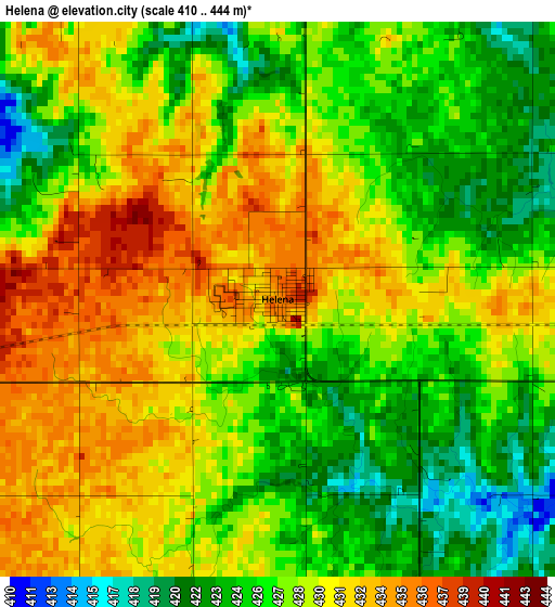
Below is the Elevation map of Helena, which displays elevation range with different colors. Scale of the first map is from 410 to 444 m (1345 to 1457 ft) with average elevation of 428 meters (=1404 ft) [note 1]
These maps also provides idea of topography and contour of this city, they are displayed at different zoom levels. More info about maps, scale and edge coordinates you can find below images.
| \ | Map #1 | Topo.Map |
| Scale [m] | 410..444 m | × |
| Scale [ft] | 1345..1457 ft | × |
| Average | 428 m = 1404 ft | × |
| Width | 7.85 km = 4.9 mi | 251.2 km = 156.1 mi |
| Height | 7.85 km = 4.9 mi | 251.2 km = 156.1 mi |
| ↑Max Latitude | 36.581437° | 37.6676° |
| Latitude at center | 36.54614° | 36.54614° |
| ↓Min Latitude | 36.510827° | 35.40817° |
| ← Min Longitude | -98.314015° | -99.67632° |
| Longitude center | -98.27007° | -98.27007° |
| →Max Longitude | -98.226125° | -96.86382° |
Nearby cities:
Cities around Helena sort by population:
• Enid elevation 388 m
38.8 km,  115°
115°
• Alva 419 m
45.6 km,  309°
309°
• Watonga 466 m
79 km,  189°
189°
• Fairview 404 m
36.1 km,  211°
211°
• Anthony 418 m
70.8 km,  17°
17°
• Hennessey 360 m
58.9 km,  145°
145°
• Cherokee 368 m
24.4 km,  341°
341°
• Waukomis 386 m
44.5 km,  131°
131°
• Okeene 376 m
48 km, 185°
• Caldwell 356 m
80 km,  47°
47°
• Kiowa 412 m
55.8 km, 339°
• Medford 338 m
55.9 km,  58°
58°
Multilingual:
 En español:
Helena elevación 436 m.
 En France:
Helena élévation 436 m.


Sources and notes:
- [note 1] Map square and city borders are not equal. Map elevation data is calculated only from area inside that square.
- [src 1] Elevation data from geonames database provided with same terms of usage.
- [src 2] The elevation map of Helena is generated using elevation data from NASA's 3 arcsec (90m) resolution SRTM data.
- [src 3] Base (background) map © OpenStreetMap contributors tiles are generated by Geofabrik and OpenTopoMap.
Copyright & License:
This Helena Elevation Map is licensed under CC BY-SA. You may reuse any part from this page, if you give a proper credit by linking to this URL:
 More info on terms of use page.