Caldwell elevation
Caldwell (Kansas, Sumner County), United States elevation is 356 meters and Caldwell elevation in feet is 1168 ft above sea level [src 1]. Caldwell is a populated place (feature code) with elevation that is 77 meters (253 ft) bigger than average city elevation in United States.
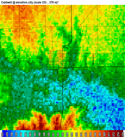
Below is the Elevation map of Caldwell, which displays elevation range with different colors. Scale of the first map is from 333 to 376 m (1093 to 1234 ft) with average elevation of 351.9 meters (=1155 ft) [note 1]
These maps also provides idea of topography and contour of this city, they are displayed at different zoom levels. More info about maps, scale and edge coordinates you can find below images.
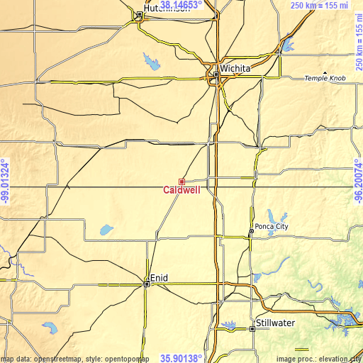
| \ | Map #1 | Topo.Map |
| Scale [m] | 333..376 m | × |
| Scale [ft] | 1093..1234 ft | × |
| Average | 351.9 m = 1155 ft | × |
| Width | 7.8 km = 4.8 mi | 249.6 km = 155.1 mi |
| Height | 7.8 km = 4.8 mi | 249.6 km = 155.1 mi |
| ↑Max Latitude | 37.067323° | 38.14653° |
| Latitude at center | 37.03225° | 37.03225° |
| ↓Min Latitude | 36.997161° | 35.90138° |
| ← Min Longitude | -97.650935° | -99.01324° |
| Longitude center | -97.60699° | -97.60699° |
| →Max Longitude | -97.563045° | -96.20074° |
Nearby cities:
Cities around Caldwell sort by population:
• Arkansas City elevation 345 m
50.6 km,  86°
86°
• Wellington 380 m
33.3 km,  38°
38°
• Blackwell 316 m
38.4 km,  131°
131°
• Tonkawa 306 m
47.4 km,  146°
146°
• Clearwater 397 m
53.1 km,  9°
9°
• Newkirk 357 m
51.9 km,  108°
108°
• Anthony 418 m
40 km,  289°
289°
• Belle Plaine 379 m
49.5 km, 35°
• Harper 436 m
46.7 km,  307°
307°
• Conway Springs 424 m
39.9 km,  355°
355°
• Oxford 366 m
47.2 km,  55°
55°
• Medford 338 m
27.5 km,  204°
204°
Multilingual:
 En español:
Caldwell elevación 356 m.
 En France:
Caldwell élévation 356 m.
 Auf Deutsch:
Caldwell höhe über dem Meeresspiegel ist 356 m.

Sources and notes:
- [note 1] Map square and city borders are not equal. Map elevation data is calculated only from area inside that square.
- [src 1] Elevation data from geonames database provided with same terms of usage.
- [src 2] The elevation map of Caldwell is generated using elevation data from NASA's 3 arcsec (90m) resolution SRTM data.
- [src 3] Base (background) map © OpenStreetMap contributors tiles are generated by Geofabrik and OpenTopoMap.
Copyright & License:
This Caldwell Elevation Map is licensed under CC BY-SA. You may reuse any part from this page, if you give a proper credit by linking to this URL:
 More info on terms of use page.