Anthony elevation
Anthony (Kansas, Harper County), United States elevation is 418 meters and Anthony elevation in feet is 1371 ft above sea level [src 1]. Anthony is a seat of a second-order administrative division (feature code) with elevation that is 139 meters (456 ft) bigger than average city elevation in United States.
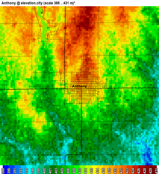
Below is the Elevation map of Anthony, which displays elevation range with different colors. Scale of the first map is from 388 to 431 m (1273 to 1414 ft) with average elevation of 408.9 meters (=1342 ft) [note 1]
These maps also provides idea of topography and contour of this city, they are displayed at different zoom levels. More info about maps, scale and edge coordinates you can find below images.
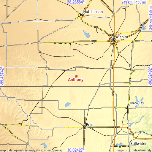
| \ | Map #1 | Topo.Map |
| Scale [m] | 388..431 m | × |
| Scale [ft] | 1273..1414 ft | × |
| Average | 408.9 m = 1342 ft | × |
| Width | 7.79 km = 4.8 mi | 249.2 km = 154.8 mi |
| Height | 7.79 km = 4.8 mi | 249.2 km = 154.8 mi |
| ↑Max Latitude | 37.188377° | 38.26584° |
| Latitude at center | 37.15336° | 37.15336° |
| ↓Min Latitude | 37.118327° | 36.02427° |
| ← Min Longitude | -98.075115° | -99.43742° |
| Longitude center | -98.03117° | -98.03117° |
| →Max Longitude | -97.987225° | -96.62492° |
Nearby cities:
Cities around Anthony sort by population:
• Wellington elevation 380 m
59.7 km,  77°
77°
• Alva 419 m
68.5 km,  235°
235°
• Kingman 471 m
55.2 km,  352°
352°
• Clearwater 397 m
60.6 km,  50°
50°
• Cheney 430 m
57.4 km,  22°
22°
• Medicine Lodge 464 m
50.7 km,  286°
286°
• Cherokee 368 m
53 km,  213°
213°
• Harper 436 m
14.8 km,  1°
1°
• Conway Springs 424 m
43.3 km, 52°
• Caldwell 356 m
40 km,  109°
109°
• Kiowa 412 m
43 km,  249°
249°
• Medford 338 m
46.7 km,  145°
145°
Multilingual:
 En español:
Anthony elevación 418 m.
 En France:
Anthony élévation 418 m.


Sources and notes:
- [note 1] Map square and city borders are not equal. Map elevation data is calculated only from area inside that square.
- [src 1] Elevation data from geonames database provided with same terms of usage.
- [src 2] The elevation map of Anthony is generated using elevation data from NASA's 3 arcsec (90m) resolution SRTM data.
- [src 3] Base (background) map © OpenStreetMap contributors tiles are generated by Geofabrik and OpenTopoMap.
Copyright & License:
This Anthony Elevation Map is licensed under CC BY-SA. You may reuse any part from this page, if you give a proper credit by linking to this URL:
 More info on terms of use page.