Kingman elevation
Kingman (Kansas, Kingman County), United States elevation is 471 meters and Kingman elevation in feet is 1545 ft above sea level [src 1]. Kingman is a seat of a second-order administrative division (feature code) with elevation that is 192 meters (630 ft) bigger than average city elevation in United States.
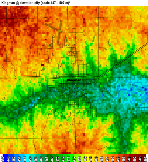
Below is the Elevation map of Kingman, which displays elevation range with different colors. Scale of the first map is from 447 to 507 m (1467 to 1663 ft) with average elevation of 480.8 meters (=1577 ft) [note 1]
These maps also provides idea of topography and contour of this city, they are displayed at different zoom levels. More info about maps, scale and edge coordinates you can find below images.
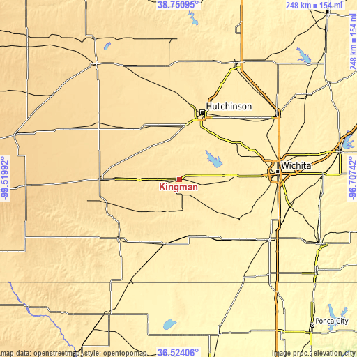
| \ | Map #1 | Topo.Map |
| Scale [m] | 447..507 m | × |
| Scale [ft] | 1467..1663 ft | × |
| Average | 480.8 m = 1577 ft | × |
| Width | 7.74 km = 4.8 mi | 247.6 km = 153.9 mi |
| Height | 7.74 km = 4.8 mi | 247.6 km = 153.9 mi |
| ↑Max Latitude | 37.680638° | 38.75095° |
| Latitude at center | 37.64585° | 37.64585° |
| ↓Min Latitude | 37.611046° | 36.52406° |
| ← Min Longitude | -98.157615° | -99.51992° |
| Longitude center | -98.11367° | -98.11367° |
| →Max Longitude | -98.069725° | -96.70742° |
Nearby cities:
Cities around Kingman sort by population:
• Hutchinson elevation 473 m
48.9 km,  19°
19°
• Pratt 582 m
54.9 km,  269°
269°
• Goddard 451 m
47.4 km,  88°
88°
• South Hutchinson 471 m
45.1 km, 19°
• Saint Marys 466 m
42.2 km,  80°
80°
• Anthony 418 m
55.2 km,  172°
172°
• Cheney 430 m
29.2 km, 93°
• Harper 436 m
40.7 km, 169°
• Colwich 428 m
52.9 km,  73°
73°
• Conway Springs 424 m
50.4 km,  124°
124°
• Haven 455 m
40.5 km,  45°
45°
• Nickerson 491 m
55.8 km,  2°
2°
Multilingual:
 En español:
Kingman elevación 471 m.
 En France:
Kingman élévation 471 m.


Sources and notes:
- [note 1] Map square and city borders are not equal. Map elevation data is calculated only from area inside that square.
- [src 1] Elevation data from geonames database provided with same terms of usage.
- [src 2] The elevation map of Kingman is generated using elevation data from NASA's 3 arcsec (90m) resolution SRTM data.
- [src 3] Base (background) map © OpenStreetMap contributors tiles are generated by Geofabrik and OpenTopoMap.
Copyright & License:
This Kingman Elevation Map is licensed under CC BY-SA. You may reuse any part from this page, if you give a proper credit by linking to this URL:
 More info on terms of use page.