Saint Marys elevation
Saint Marys (Kansas, Sedgwick County), United States elevation is 466 meters and Saint Marys elevation in feet is 1529 ft above sea level [src 1]. Saint Marys is a populated place (feature code) with elevation that is 187 meters (614 ft) bigger than average city elevation in United States.
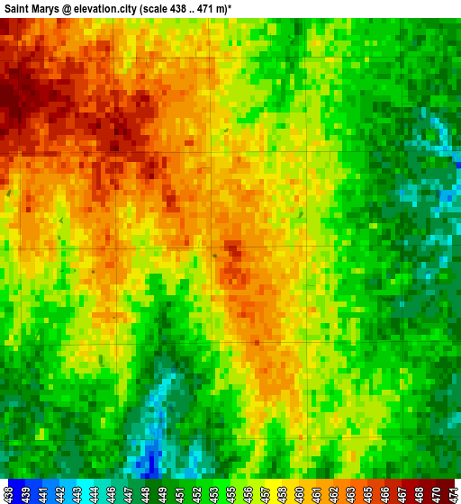
Below is the Elevation map of Saint Marys, which displays elevation range with different colors. Scale of the first map is from 438 to 471 m (1437 to 1545 ft) with average elevation of 455.7 meters (=1495 ft) [note 1]
These maps also provides idea of topography and contour of this city, they are displayed at different zoom levels. More info about maps, scale and edge coordinates you can find below images.
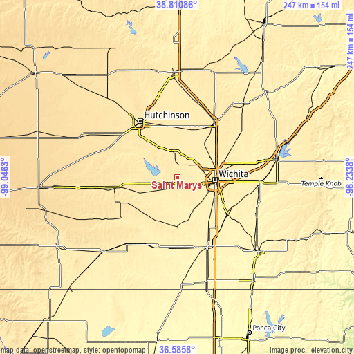
| \ | Map #1 | Topo.Map |
| Scale [m] | 438..471 m | × |
| Scale [ft] | 1437..1545 ft | × |
| Average | 455.7 m = 1495 ft | × |
| Width | 7.73 km = 4.8 mi | 247.4 km = 153.7 mi |
| Height | 7.73 km = 4.8 mi | 247.4 km = 153.7 mi |
| ↑Max Latitude | 37.741439° | 38.81086° |
| Latitude at center | 37.70668° | 37.70668° |
| ↓Min Latitude | 37.671904° | 36.5858° |
| ← Min Longitude | -97.683995° | -99.0463° |
| Longitude center | -97.64005° | -97.64005° |
| →Max Longitude | -97.596105° | -96.2338° |
Nearby cities:
Cities around Saint Marys sort by population:
• Wichita elevation 402 m
26.7 km,  93°
93°
• Haysville 390 m
29.9 km,  121°
121°
• Park City 421 m
30.1 km,  69°
69°
• Valley Center 418 m
27.4 km,  58°
58°
• Goddard 451 m
7.7 km,  132°
132°
• Maize 420 m
17.2 km, 62°
• Clearwater 397 m
25.6 km,  152°
152°
• Cheney 430 m
15.2 km,  235°
235°
• Kechi 427 m
33.2 km, 72°
• Sedgwick 426 m
30.2 km,  39°
39°
• Colwich 428 m
12.2 km,  48°
48°
• Haven 455 m
24.8 km,  329°
329°
Multilingual:
 En español:
Saint Marys elevación 466 m.
 En France:
Saint Marys élévation 466 m.
 Auf Deutsch:
Saint Marys höhe über dem Meeresspiegel ist 466 m.

Sources and notes:
- [note 1] Map square and city borders are not equal. Map elevation data is calculated only from area inside that square.
- [src 1] Elevation data from geonames database provided with same terms of usage.
- [src 2] The elevation map of Saint Marys is generated using elevation data from NASA's 3 arcsec (90m) resolution SRTM data.
- [src 3] Base (background) map © OpenStreetMap contributors tiles are generated by Geofabrik and OpenTopoMap.
Copyright & License:
This Saint Marys Elevation Map is licensed under CC BY-SA. You may reuse any part from this page, if you give a proper credit by linking to this URL:
 More info on terms of use page.