Pratt elevation
Pratt (Kansas, Pratt County), United States elevation is 582 meters and Pratt elevation in feet is 1909 ft above sea level [src 1]. Pratt is a seat of a second-order administrative division (feature code) with elevation that is 303 meters (994 ft) bigger than average city elevation in United States.
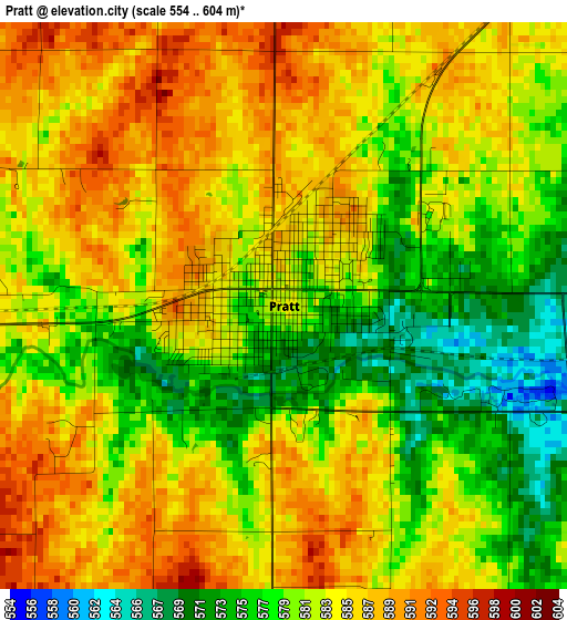
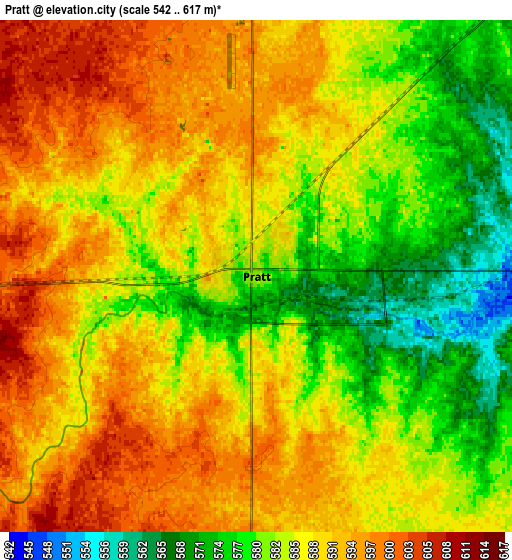
Below is the Elevation map of Pratt, which displays elevation range with different colors. Scale of the first map is from 554 to 604 m (1818 to 1982 ft) with average elevation of 582.3 meters (=1910 ft) [note 1]
These maps also provides idea of topography and contour of this city, they are displayed at different zoom levels. More info about maps, scale and edge coordinates you can find below images.
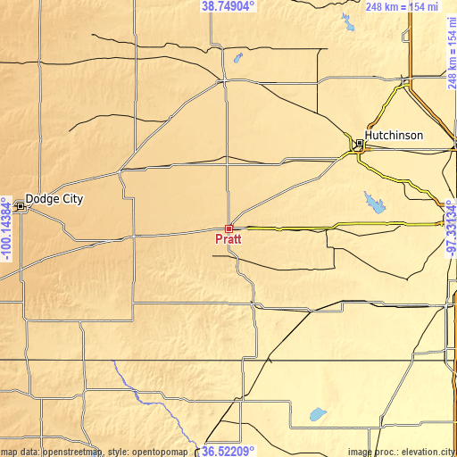
| \ | Map #1 | Map #2 | Topo.Map |
| Scale [m] | 554..604 m | 542..617 m | × |
| Scale [ft] | 1818..1982 ft | 1778..2024 ft | × |
| Average | 582.3 m = 1910 ft | 586.5 m = 1924 ft | × |
| Width | 7.74 km = 4.8 mi | 15.48 km = 9.6 mi | 247.6 km = 153.9 mi |
| Height | 7.74 km = 4.8 mi | 15.48 km = 9.6 mi | 247.6 km = 153.9 mi |
| ↑Max Latitude | 37.678699° | 37.713471° | 38.74904° |
| Latitude at center | 37.64391° | 37.64391° | 37.64391° |
| ↓Min Latitude | 37.609105° | 37.574284° | 36.52209° |
| ← Min Longitude | -98.781535° | -98.825481° | -100.14384° |
| Longitude center | -98.73759° | -98.73759° | -98.73759° |
| →Max Longitude | -98.693645° | -98.649699° | -97.33134° |
Nearby cities:
Cities around Pratt sort by population:
• Great Bend elevation 572 m
80.2 km,  358°
358°
• Larned 619 m
67.6 km,  332°
332°
• Kingman 471 m
54.9 km,  89°
89°
• Sterling 504 m
78.3 km,  36°
36°
• Medicine Lodge 464 m
42.7 km,  161°
161°
• Kinsley 667 m
66.7 km,  297°
297°
• Harper 436 m
74.3 km,  122°
122°
• Saint John 590 m
39.9 km, 357°
• Nickerson 491 m
80.1 km,  45°
45°
• Kiowa 412 m
73.2 km, 162°
• Coldwater 648 m
66.7 km,  231°
231°
• Greensburg 691 m
49.1 km,  264°
264°
Multilingual:
 En español:
Pratt elevación 582 m.
 En France:
Pratt élévation 582 m.


Sources and notes:
- [note 1] Map square and city borders are not equal. Map elevation data is calculated only from area inside that square.
- [src 1] Elevation data from geonames database provided with same terms of usage.
- [src 2] The elevation map of Pratt is generated using elevation data from NASA's 3 arcsec (90m) resolution SRTM data.
- [src 3] Base (background) map © OpenStreetMap contributors tiles are generated by Geofabrik and OpenTopoMap.
Copyright & License:
This Pratt Elevation Map is licensed under CC BY-SA. You may reuse any part from this page, if you give a proper credit by linking to this URL:
 More info on terms of use page.