Great Bend elevation
Great Bend (Kansas, Barton County), United States elevation is 572 meters and Great Bend elevation in feet is 1877 ft above sea level [src 1]. Great Bend is a seat of a second-order administrative division (feature code) with elevation that is 293 meters (961 ft) bigger than average city elevation in United States.
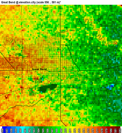
Below is the Elevation map of Great Bend, which displays elevation range with different colors. Scale of the first map is from 556 to 581 m (1824 to 1906 ft) with average elevation of 569.3 meters (=1868 ft) [note 1]
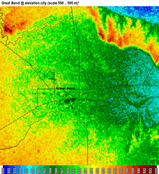
These maps also provides idea of topography and contour of this city, they are displayed at different zoom levels. More info about maps, scale and edge coordinates you can find below images.
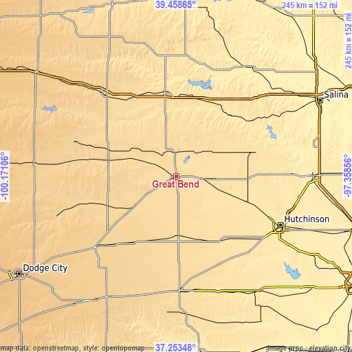
| \ | Map #1 | Map #2 | Topo.Map |
| Scale [m] | 556..581 m | 550..595 m | × |
| Scale [ft] | 1824..1906 ft | 1804..1952 ft | × |
| Average | 569.3 m = 1868 ft | 571.7 m = 1876 ft | × |
| Width | 7.66 km = 4.8 mi | 15.32 km = 9.5 mi | 245.2 km = 152.4 mi |
| Height | 7.66 km = 4.8 mi | 15.32 km = 9.5 mi | 245.2 km = 152.4 mi |
| ↑Max Latitude | 38.398908° | 38.43334° | 39.45865° |
| Latitude at center | 38.36446° | 38.36446° | 38.36446° |
| ↓Min Latitude | 38.329995° | 38.295514° | 37.25348° |
| ← Min Longitude | -98.808755° | -98.852701° | -100.17106° |
| Longitude center | -98.76481° | -98.76481° | -98.76481° |
| →Max Longitude | -98.720865° | -98.676919° | -97.35856° |
Nearby cities:
Cities around Great Bend sort by population:
• Russell elevation 563 m
59.6 km,  351°
351°
• Larned 619 m
35.6 km,  234°
234°
• Lyons 520 m
49.1 km,  92°
92°
• Ellsworth 476 m
61.9 km,  48°
48°
• Hoisington 570 m
17.1 km,  356°
356°
• Sterling 504 m
51.6 km,  109°
109°
• Ellinwood 552 m
16.1 km, 93°
• Kinsley 667 m
74.8 km, 228°
• Saint John 590 m
40.3 km,  179°
179°
• La Crosse 632 m
50.9 km,  291°
291°
• Victoria 592 m
63.7 km,  328°
328°
• Nickerson 491 m
64.2 km, 112°
Multilingual:
 En español:
Great Bend elevación 572 m.
 En France:
Great Bend élévation 572 m.
 Auf Deutsch:
Great Bend höhe über dem Meeresspiegel ist 572 m.

Sources and notes:
- [note 1] Map square and city borders are not equal. Map elevation data is calculated only from area inside that square.
- [src 1] Elevation data from geonames database provided with same terms of usage.
- [src 2] The elevation map of Great Bend is generated using elevation data from NASA's 3 arcsec (90m) resolution SRTM data.
- [src 3] Base (background) map © OpenStreetMap contributors tiles are generated by Geofabrik and OpenTopoMap.
Copyright & License:
This Great Bend Elevation Map is licensed under CC BY-SA. You may reuse any part from this page, if you give a proper credit by linking to this URL:
 More info on terms of use page.