La Crosse elevation
La Crosse (Kansas, Rush County), United States elevation is 632 meters and La Crosse elevation in feet is 2073 ft above sea level [src 1]. La Crosse is a seat of a second-order administrative division (feature code) with elevation that is 353 meters (1158 ft) bigger than average city elevation in United States.
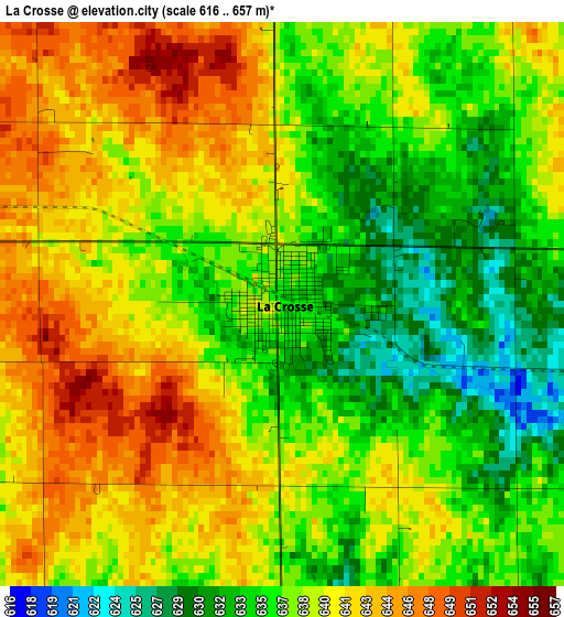
Below is the Elevation map of La Crosse, which displays elevation range with different colors. Scale of the first map is from 616 to 657 m (2021 to 2156 ft) with average elevation of 638.4 meters (=2094 ft) [note 1]
These maps also provides idea of topography and contour of this city, they are displayed at different zoom levels. More info about maps, scale and edge coordinates you can find below images.
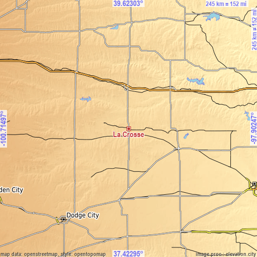
| \ | Map #1 | Topo.Map |
| Scale [m] | 616..657 m | × |
| Scale [ft] | 2021..2156 ft | × |
| Average | 638.4 m = 2094 ft | × |
| Width | 7.64 km = 4.7 mi | 244.6 km = 152 mi |
| Height | 7.64 km = 4.7 mi | 244.6 km = 152 mi |
| ↑Max Latitude | 38.565769° | 39.62303° |
| Latitude at center | 38.5314° | 38.5314° |
| ↓Min Latitude | 38.497015° | 37.42295° |
| ← Min Longitude | -99.352665° | -100.71497° |
| Longitude center | -99.30872° | -99.30872° |
| →Max Longitude | -99.264775° | -97.90247° |
Nearby cities:
Cities around La Crosse sort by population:
• Hays elevation 624 m
38.7 km,  357°
357°
• Great Bend 572 m
50.9 km,  111°
111°
• Russell 563 m
56.1 km,  43°
43°
• Larned 619 m
43.1 km,  154°
154°
• Hoisington 570 m
46.2 km,  91°
91°
• Ellinwood 552 m
66.3 km, 107°
• Ellis 654 m
50.2 km,  334°
334°
• WaKeeney 754 m
73.9 km,  317°
317°
• Kinsley 667 m
68.2 km,  187°
187°
• Ness City 695 m
52.8 km,  260°
260°
• Victoria 592 m
38.4 km,  21°
21°
• Jetmore 714 m
71.2 km,  225°
225°
Multilingual:
 En español:
La Crosse elevación 632 m.
 En France:
La Crosse élévation 632 m.
 Auf Deutsch:
La Crosse höhe über dem Meeresspiegel ist 632 m.

Sources and notes:
- [note 1] Map square and city borders are not equal. Map elevation data is calculated only from area inside that square.
- [src 1] Elevation data from geonames database provided with same terms of usage.
- [src 2] The elevation map of La Crosse is generated using elevation data from NASA's 3 arcsec (90m) resolution SRTM data.
- [src 3] Base (background) map © OpenStreetMap contributors tiles are generated by Geofabrik and OpenTopoMap.
Copyright & License:
This La Crosse Elevation Map is licensed under CC BY-SA. You may reuse any part from this page, if you give a proper credit by linking to this URL:
 More info on terms of use page.