Jetmore elevation
Jetmore (Kansas, Hodgeman County), United States elevation is 714 meters and Jetmore elevation in feet is 2343 ft above sea level [src 1]. Jetmore is a seat of a second-order administrative division (feature code) with elevation that is 435 meters (1427 ft) bigger than average city elevation in United States.
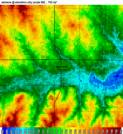
Below is the Elevation map of Jetmore, which displays elevation range with different colors. Scale of the first map is from 682 to 753 m (2238 to 2470 ft) with average elevation of 715.9 meters (=2349 ft) [note 1]
These maps also provides idea of topography and contour of this city, they are displayed at different zoom levels. More info about maps, scale and edge coordinates you can find below images.
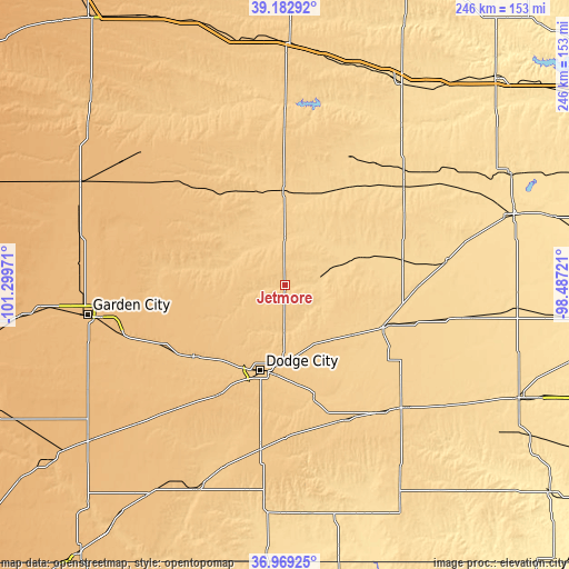
| \ | Map #1 | Topo.Map |
| Scale [m] | 682..753 m | × |
| Scale [ft] | 2238..2470 ft | × |
| Average | 715.9 m = 2349 ft | × |
| Width | 7.69 km = 4.8 mi | 246.1 km = 152.9 mi |
| Height | 7.69 km = 4.8 mi | 246.1 km = 152.9 mi |
| ↑Max Latitude | 38.119041° | 39.18292° |
| Latitude at center | 38.08446° | 38.08446° |
| ↓Min Latitude | 38.049862° | 36.96925° |
| ← Min Longitude | -99.937405° | -101.29971° |
| Longitude center | -99.89346° | -99.89346° |
| →Max Longitude | -99.849515° | -98.48721° |
Nearby cities:
Cities around Jetmore sort by population:
• Dodge City elevation 767 m
38.4 km,  196°
196°
• Garden City 870 m
86.7 km,  261°
261°
• Larned 619 m
70.3 km,  81°
81°
• Scott City 913 m
98.9 km,  296°
296°
• Cimarron 815 m
50.4 km,  232°
232°
• Holcomb 884 m
96.6 km, 263°
• Meade 771 m
97.1 km, 203°
• Kinsley 667 m
46 km,  112°
112°
• Ness City 695 m
41 km,  358°
358°
• La Crosse 632 m
71.2 km,  45°
45°
• Dighton 850 m
66.8 km,  311°
311°
• Greensburg 691 m
75.2 km,  135°
135°
Multilingual:
 En español:
Jetmore elevación 714 m.
 En France:
Jetmore élévation 714 m.


Sources and notes:
- [note 1] Map square and city borders are not equal. Map elevation data is calculated only from area inside that square.
- [src 1] Elevation data from geonames database provided with same terms of usage.
- [src 2] The elevation map of Jetmore is generated using elevation data from NASA's 3 arcsec (90m) resolution SRTM data.
- [src 3] Base (background) map © OpenStreetMap contributors tiles are generated by Geofabrik and OpenTopoMap.
Copyright & License:
This Jetmore Elevation Map is licensed under CC BY-SA. You may reuse any part from this page, if you give a proper credit by linking to this URL:
 More info on terms of use page.