Dighton elevation
Dighton (Kansas, Lane County), United States elevation is 850 meters and Dighton elevation in feet is 2789 ft above sea level [src 1]. Dighton is a seat of a second-order administrative division (feature code) with elevation that is 571 meters (1873 ft) bigger than average city elevation in United States.
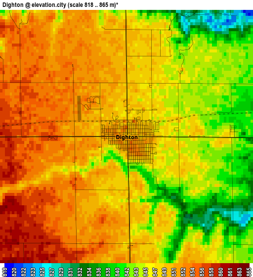
Below is the Elevation map of Dighton, which displays elevation range with different colors. Scale of the first map is from 818 to 865 m (2684 to 2838 ft) with average elevation of 847.8 meters (=2781 ft) [note 1]
These maps also provides idea of topography and contour of this city, they are displayed at different zoom levels. More info about maps, scale and edge coordinates you can find below images.
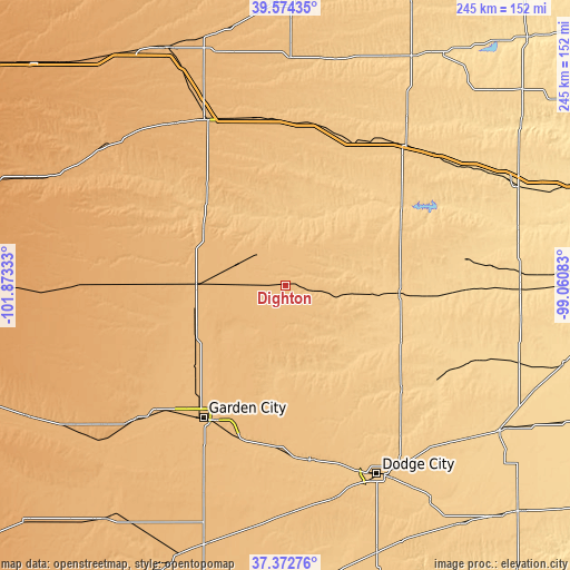
| \ | Map #1 | Topo.Map |
| Scale [m] | 818..865 m | × |
| Scale [ft] | 2684..2838 ft | × |
| Average | 847.8 m = 2781 ft | × |
| Width | 7.65 km = 4.8 mi | 244.8 km = 152.1 mi |
| Height | 7.65 km = 4.8 mi | 244.8 km = 152.1 mi |
| ↑Max Latitude | 38.516352° | 39.57435° |
| Latitude at center | 38.48196° | 38.48196° |
| ↓Min Latitude | 38.447551° | 37.37276° |
| ← Min Longitude | -100.511025° | -101.87333° |
| Longitude center | -100.46708° | -100.46708° |
| →Max Longitude | -100.423135° | -99.06083° |
Nearby cities:
Cities around Dighton sort by population:
• Dodge City elevation 767 m
90.1 km,  154°
154°
• Garden City 870 m
66.9 km,  211°
211°
• Scott City 913 m
38.3 km,  270°
270°
• Cimarron 815 m
75.8 km,  172°
172°
• Lakin 920 m
91.4 km,  228°
228°
• Holcomb 884 m
71.6 km,  219°
219°
• Oakley 936 m
80.2 km,  334°
334°
• WaKeeney 754 m
79 km,  40°
40°
• Leoti 1014 m
77.6 km, 269°
• Ness City 695 m
48.9 km,  93°
93°
• Jetmore 714 m
66.8 km,  131°
131°
• Gove 807 m
52.9 km,  357°
357°
Multilingual:
 En español:
Dighton elevación 850 m.
 En France:
Dighton élévation 850 m.


Sources and notes:
- [note 1] Map square and city borders are not equal. Map elevation data is calculated only from area inside that square.
- [src 1] Elevation data from geonames database provided with same terms of usage.
- [src 2] The elevation map of Dighton is generated using elevation data from NASA's 3 arcsec (90m) resolution SRTM data.
- [src 3] Base (background) map © OpenStreetMap contributors tiles are generated by Geofabrik and OpenTopoMap.
Copyright & License:
This Dighton Elevation Map is licensed under CC BY-SA. You may reuse any part from this page, if you give a proper credit by linking to this URL:
 More info on terms of use page.