Alva elevation
Alva (Oklahoma, Woods County), United States elevation is 419 meters and Alva elevation in feet is 1375 ft above sea level [src 1]. Alva is a seat of a second-order administrative division (feature code) with elevation that is 140 meters (459 ft) bigger than average city elevation in United States.
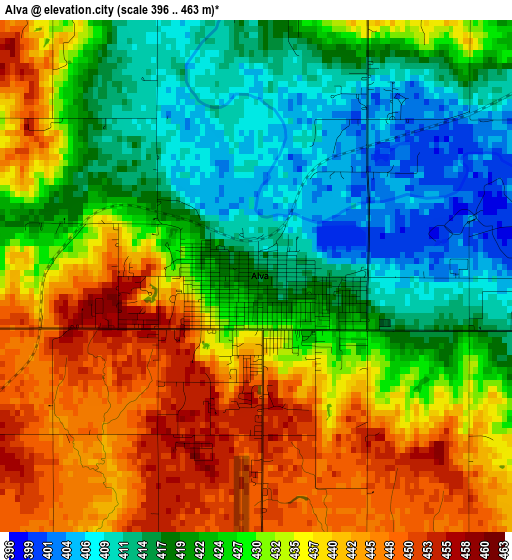
Below is the Elevation map of Alva, which displays elevation range with different colors. Scale of the first map is from 396 to 463 m (1299 to 1519 ft) with average elevation of 428.5 meters (=1406 ft) [note 1]
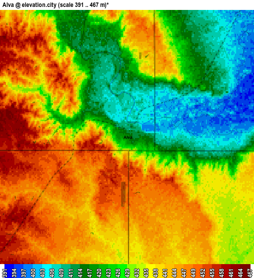
These maps also provides idea of topography and contour of this city, they are displayed at different zoom levels. More info about maps, scale and edge coordinates you can find below images.
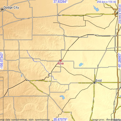
| \ | Map #1 | Map #2 | Topo.Map |
| Scale [m] | 396..463 m | 391..467 m | × |
| Scale [ft] | 1299..1519 ft | 1283..1532 ft | × |
| Average | 428.5 m = 1406 ft | 432.7 m = 1420 ft | × |
| Width | 7.82 km = 4.9 mi | 15.65 km = 9.7 mi | 250.4 km = 155.6 mi |
| Height | 7.82 km = 4.9 mi | 15.65 km = 9.7 mi | 250.4 km = 155.6 mi |
| ↑Max Latitude | 36.840168° | 36.87533° | 37.92264° |
| Latitude at center | 36.80499° | 36.80499° | 36.80499° |
| ↓Min Latitude | 36.769796° | 36.734585° | 35.67079° |
| ← Min Longitude | -98.711125° | -98.755071° | -100.07343° |
| Longitude center | -98.66718° | -98.66718° | -98.66718° |
| →Max Longitude | -98.623235° | -98.579289° | -97.26093° |
Nearby cities:
Cities around Alva sort by population:
• Woodward elevation 589 m
76.6 km,  237°
237°
• Fairview 404 m
61.9 km,  164°
164°
• Anthony 418 m
68.5 km,  55°
55°
• Medicine Lodge 464 m
53.5 km,  8°
8°
• Cherokee 368 m
28.2 km,  101°
101°
• Helena 436 m
45.6 km,  129°
129°
• Harper 436 m
78.2 km,  46°
46°
• Mooreland 587 m
62.9 km,  229°
229°
• Okeene 376 m
82.7 km, 157°
• Kiowa 412 m
28.6 km,  34°
34°
• Medford 338 m
83.1 km,  89°
89°
• Coldwater 648 m
78 km,  311°
311°
Multilingual:
 En español:
Alva elevación 419 m.
 En France:
Alva élévation 419 m.


Sources and notes:
- [note 1] Map square and city borders are not equal. Map elevation data is calculated only from area inside that square.
- [src 1] Elevation data from geonames database provided with same terms of usage.
- [src 2] The elevation map of Alva is generated using elevation data from NASA's 3 arcsec (90m) resolution SRTM data.
- [src 3] Base (background) map © OpenStreetMap contributors tiles are generated by Geofabrik and OpenTopoMap.
Copyright & License:
This Alva Elevation Map is licensed under CC BY-SA. You may reuse any part from this page, if you give a proper credit by linking to this URL:
 More info on terms of use page.