Buffalo elevation
Buffalo (Oklahoma, Harper County), United States elevation is 561 meters and Buffalo elevation in feet is 1841 ft above sea level [src 1]. Buffalo is a seat of a second-order administrative division (feature code) with elevation that is 282 meters (925 ft) bigger than average city elevation in United States.
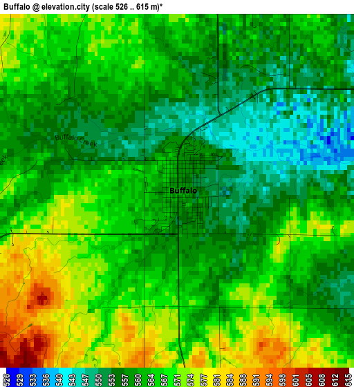
Below is the Elevation map of Buffalo, which displays elevation range with different colors. Scale of the first map is from 526 to 615 m (1726 to 2018 ft) with average elevation of 563.3 meters (=1848 ft) [note 1]
These maps also provides idea of topography and contour of this city, they are displayed at different zoom levels. More info about maps, scale and edge coordinates you can find below images.
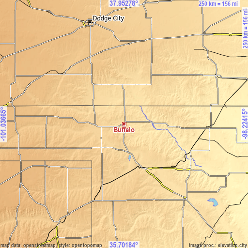
| \ | Map #1 | Topo.Map |
| Scale [m] | 526..615 m | × |
| Scale [ft] | 1726..2018 ft | × |
| Average | 563.3 m = 1848 ft | × |
| Width | 7.82 km = 4.9 mi | 250.3 km = 155.5 mi |
| Height | 7.82 km = 4.9 mi | 250.3 km = 155.5 mi |
| ↑Max Latitude | 36.870754° | 37.95278° |
| Latitude at center | 36.83559° | 36.83559° |
| ↓Min Latitude | 36.80041° | 35.70184° |
| ← Min Longitude | -99.674345° | -101.03665° |
| Longitude center | -99.6304° | -99.6304° |
| →Max Longitude | -99.586455° | -98.22415° |
Nearby cities:
Cities around Buffalo sort by population:
• Woodward elevation 589 m
49.6 km,  154°
154°
• Alva 419 m
85.8 km,  92°
92°
• Booker 870 m
91.4 km,  242°
242°
• Meade 771 m
80.4 km,  308°
308°
• Beaver 740 m
79.2 km,  268°
268°
• Shattuck 691 m
66.2 km,  199°
199°
• Laverne 651 m
27.3 km, 239°
• Mooreland 587 m
58.2 km,  139°
139°
• Ashland 611 m
41.1 km,  342°
342°
• Coldwater 648 m
55.2 km,  29°
29°
• Greensburg 691 m
90.4 km,  19°
19°
• Arnett 755 m
79 km,  189°
189°
Multilingual:
 En español:
Buffalo elevación 561 m.
 En France:
Buffalo élévation 561 m.


Sources and notes:
- [note 1] Map square and city borders are not equal. Map elevation data is calculated only from area inside that square.
- [src 1] Elevation data from geonames database provided with same terms of usage.
- [src 2] The elevation map of Buffalo is generated using elevation data from NASA's 3 arcsec (90m) resolution SRTM data.
- [src 3] Base (background) map © OpenStreetMap contributors tiles are generated by Geofabrik and OpenTopoMap.
Copyright & License:
This Buffalo Elevation Map is licensed under CC BY-SA. You may reuse any part from this page, if you give a proper credit by linking to this URL:
 More info on terms of use page.