Kenwood elevation
Kenwood (Oklahoma, Delaware County), United States elevation is 233 meters and Kenwood elevation in feet is 764 ft above sea level [src 1]. Kenwood is a populated place (feature code) with elevation that is 46 meters (151 ft) smaller than average city elevation in United States.
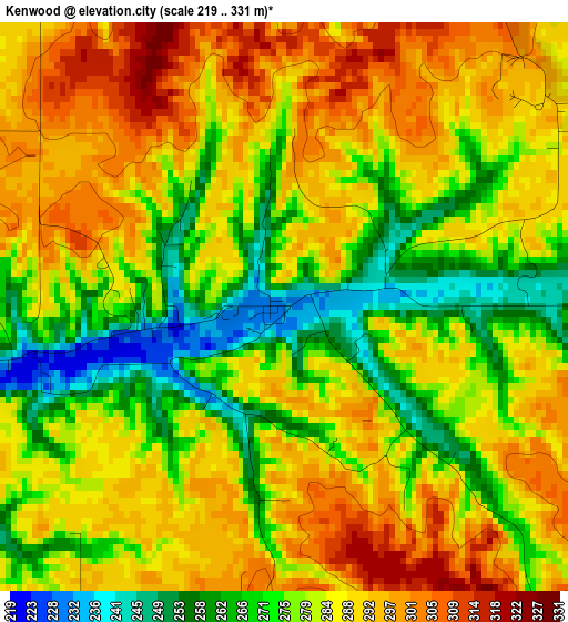
Below is the Elevation map of Kenwood, which displays elevation range with different colors. Scale of the first map is from 219 to 331 m (719 to 1086 ft) with average elevation of 282.5 meters (=927 ft) [note 1]
These maps also provides idea of topography and contour of this city, they are displayed at different zoom levels. More info about maps, scale and edge coordinates you can find below images.
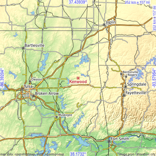
| \ | Map #1 | Topo.Map |
| Scale [m] | 219..331 m | × |
| Scale [ft] | 719..1086 ft | × |
| Average | 282.5 m = 927 ft | × |
| Width | 7.87 km = 4.9 mi | 252 km = 156.6 mi |
| Height | 7.87 km = 4.9 mi | 252 km = 156.6 mi |
| ↑Max Latitude | 36.349932° | 37.43939° |
| Latitude at center | 36.31453° | 36.31453° |
| ↓Min Latitude | 36.279112° | 35.1732° |
| ← Min Longitude | -95.029735° | -96.39204° |
| Longitude center | -94.98579° | -94.98579° |
| →Max Longitude | -94.941845° | -93.57954° |
Nearby cities:
Cities around Kenwood sort by population:
• Siloam Springs elevation 349 m
42.3 km,  109°
109°
• Pryor Creek 194 m
29.8 km,  268°
268°
• Pryor 195 m
29.7 km, 268°
• Grove 240 m
36.6 km,  31°
31°
• Vinita 215 m
39.1 km,  337°
337°
• Jay 318 m
20.7 km,  54°
54°
• Chouteau 193 m
35.1 km,  245°
245°
• Copeland 242 m
40.5 km,  20°
20°
• Cleora 244 m
29.4 km,  2°
2°
• Locust Grove 207 m
20.7 km,  232°
232°
• Salina 197 m
15.2 km,  260°
260°
• Afton 242 m
42.2 km, 2°
Multilingual:
 En español:
Kenwood elevación 233 m.
 En France:
Kenwood élévation 233 m.


Sources and notes:
- [note 1] Map square and city borders are not equal. Map elevation data is calculated only from area inside that square.
- [src 1] Elevation data from geonames database provided with same terms of usage.
- [src 2] The elevation map of Kenwood is generated using elevation data from NASA's 3 arcsec (90m) resolution SRTM data.
- [src 3] Base (background) map © OpenStreetMap contributors tiles are generated by Geofabrik and OpenTopoMap.
Copyright & License:
This Kenwood Elevation Map is licensed under CC BY-SA. You may reuse any part from this page, if you give a proper credit by linking to this URL:
 More info on terms of use page.