Grove elevation
Grove (Oklahoma, Delaware County), United States elevation is 240 meters and Grove elevation in feet is 787 ft above sea level [src 1]. Grove is a populated place (feature code) with elevation that is 39 meters (128 ft) smaller than average city elevation in United States.
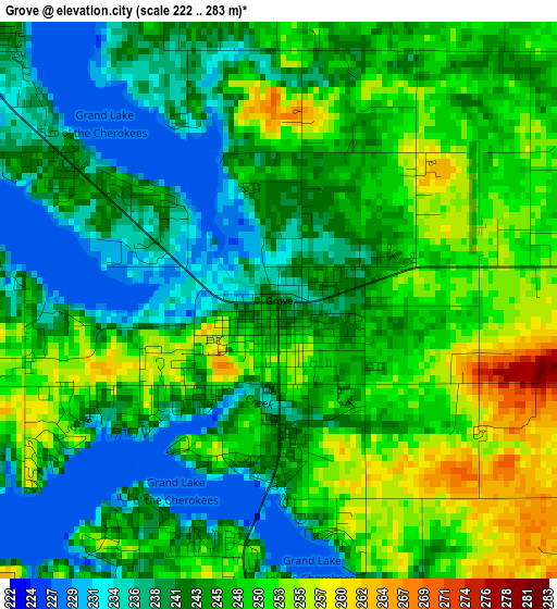
Below is the Elevation map of Grove, which displays elevation range with different colors. Scale of the first map is from 222 to 283 m (728 to 928 ft) with average elevation of 245 meters (=804 ft) [note 1]
These maps also provides idea of topography and contour of this city, they are displayed at different zoom levels. More info about maps, scale and edge coordinates you can find below images.
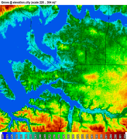
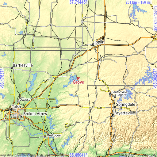
| \ | Map #1 | Map #2 | Topo.Map |
| Scale [m] | 222..283 m | 220..304 m | × |
| Scale [ft] | 728..928 ft | 722..997 ft | × |
| Average | 245 m = 804 ft | 248.3 m = 815 ft | × |
| Width | 7.85 km = 4.9 mi | 15.69 km = 9.7 mi | 251.1 km = 156 mi |
| Height | 7.85 km = 4.9 mi | 15.69 km = 9.7 mi | 251.1 km = 156 mi |
| ↑Max Latitude | 36.628965° | 36.664224° | 37.71445° |
| Latitude at center | 36.59369° | 36.59369° | 36.59369° |
| ↓Min Latitude | 36.558399° | 36.523092° | 35.45641° |
| ← Min Longitude | -94.813065° | -94.857011° | -96.17537° |
| Longitude center | -94.76912° | -94.76912° | -94.76912° |
| →Max Longitude | -94.725175° | -94.681229° | -93.36287° |
Nearby cities:
Cities around Grove sort by population:
• Miami elevation 247 m
32.7 km,  342°
342°
• Vinita 215 m
34.7 km,  278°
278°
• Gravette 373 m
34.1 km,  124°
124°
• Jay 318 m
19.3 km,  187°
187°
• Seneca 261 m
30.9 km,  27°
27°
• Anderson 271 m
29.7 km,  77°
77°
• Noel 258 m
25.9 km,  101°
101°
• Copeland 242 m
8.7 km,  322°
322°
• Cleora 244 m
18.1 km,  264°
264°
• Fairland 257 m
18.9 km, 338°
• Afton 242 m
20.6 km,  302°
302°
• Pineville 277 m
34.4 km,  89°
89°
Multilingual:
 En español:
Grove elevación 240 m.
 En France:
Grove élévation 240 m.


Sources and notes:
- [note 1] Map square and city borders are not equal. Map elevation data is calculated only from area inside that square.
- [src 1] Elevation data from geonames database provided with same terms of usage.
- [src 2] The elevation map of Grove is generated using elevation data from NASA's 3 arcsec (90m) resolution SRTM data.
- [src 3] Base (background) map © OpenStreetMap contributors tiles are generated by Geofabrik and OpenTopoMap.
Copyright & License:
This Grove Elevation Map is licensed under CC BY-SA. You may reuse any part from this page, if you give a proper credit by linking to this URL:
 More info on terms of use page.