Cleora elevation
Cleora (Oklahoma, Delaware County), United States elevation is 244 meters and Cleora elevation in feet is 801 ft above sea level [src 1]. Cleora is a populated place (feature code) with elevation that is 35 meters (115 ft) smaller than average city elevation in United States.
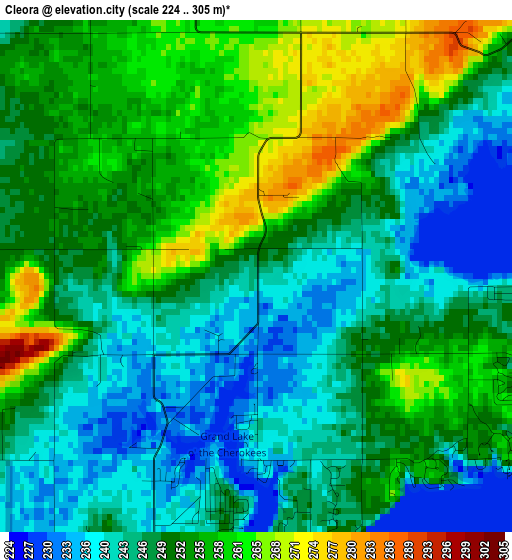
Below is the Elevation map of Cleora, which displays elevation range with different colors. Scale of the first map is from 224 to 305 m (735 to 1001 ft) with average elevation of 249.8 meters (=820 ft) [note 1]
These maps also provides idea of topography and contour of this city, they are displayed at different zoom levels. More info about maps, scale and edge coordinates you can find below images.
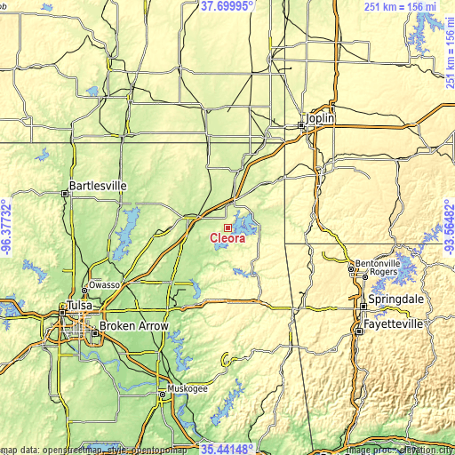
| \ | Map #1 | Topo.Map |
| Scale [m] | 224..305 m | × |
| Scale [ft] | 735..1001 ft | × |
| Average | 249.8 m = 820 ft | × |
| Width | 7.85 km = 4.9 mi | 251.1 km = 156 mi |
| Height | 7.85 km = 4.9 mi | 251.1 km = 156 mi |
| ↑Max Latitude | 36.614252° | 37.69995° |
| Latitude at center | 36.57897° | 36.57897° |
| ↓Min Latitude | 36.543672° | 35.44148° |
| ← Min Longitude | -95.015015° | -96.37732° |
| Longitude center | -94.97107° | -94.97107° |
| →Max Longitude | -94.927125° | -93.56482° |
Nearby cities:
Cities around Cleora sort by population:
• Miami elevation 247 m
33.9 km,  14°
14°
• Pryor 195 m
43.1 km,  225°
225°
• Grove 240 m
18.1 km,  84°
84°
• Vinita 215 m
17.6 km,  292°
292°
• Commerce 249 m
40.4 km, 12°
• Jay 318 m
23.5 km,  138°
138°
• Chelsea 222 m
41.5 km,  263°
263°
• Copeland 242 m
15.3 km,  56°
56°
• Salina 197 m
35.7 km,  207°
207°
• Kenwood 233 m
29.4 km,  182°
182°
• Fairland 257 m
22.1 km,  29°
29°
• Afton 242 m
12.8 km,  3°
3°
Multilingual:
 En español:
Cleora elevación 244 m.
 En France:
Cleora élévation 244 m.


Sources and notes:
- [note 1] Map square and city borders are not equal. Map elevation data is calculated only from area inside that square.
- [src 1] Elevation data from geonames database provided with same terms of usage.
- [src 2] The elevation map of Cleora is generated using elevation data from NASA's 3 arcsec (90m) resolution SRTM data.
- [src 3] Base (background) map © OpenStreetMap contributors tiles are generated by Geofabrik and OpenTopoMap.
Copyright & License:
This Cleora Elevation Map is licensed under CC BY-SA. You may reuse any part from this page, if you give a proper credit by linking to this URL:
 More info on terms of use page.