Seneca elevation
Seneca (Missouri, Newton County), United States elevation is 261 meters and Seneca elevation in feet is 856 ft above sea level [src 1]. Seneca is a populated place (feature code) with elevation that is 18 meters (59 ft) smaller than average city elevation in United States.
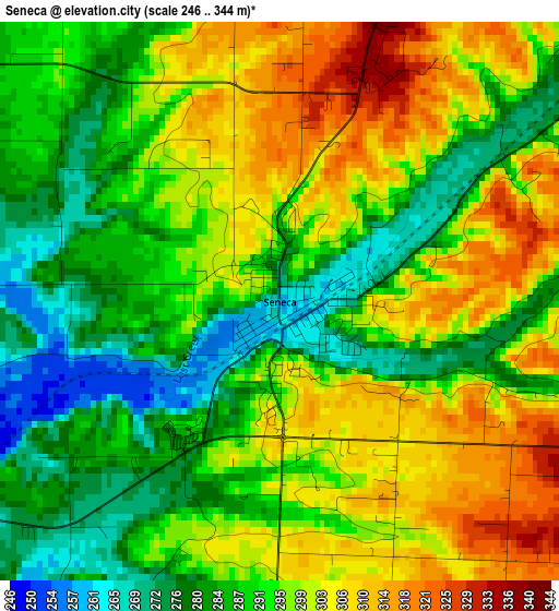
Below is the Elevation map of Seneca, which displays elevation range with different colors. Scale of the first map is from 246 to 344 m (807 to 1129 ft) with average elevation of 293.7 meters (=964 ft) [note 1]
These maps also provides idea of topography and contour of this city, they are displayed at different zoom levels. More info about maps, scale and edge coordinates you can find below images.
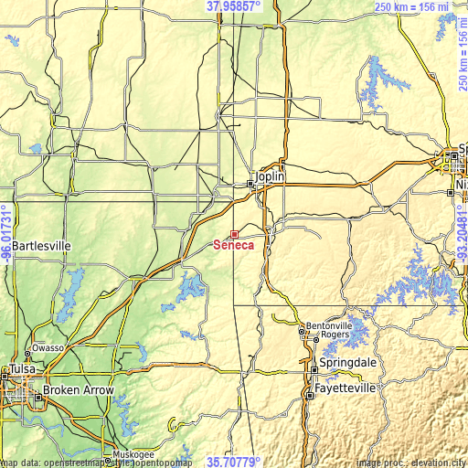
| \ | Map #1 | Topo.Map |
| Scale [m] | 246..344 m | × |
| Scale [ft] | 807..1129 ft | × |
| Average | 293.7 m = 964 ft | × |
| Width | 7.82 km = 4.9 mi | 250.3 km = 155.5 mi |
| Height | 7.82 km = 4.9 mi | 250.3 km = 155.5 mi |
| ↑Max Latitude | 36.876621° | 37.95857° |
| Latitude at center | 36.84146° | 36.84146° |
| ↓Min Latitude | 36.806283° | 35.70779° |
| ← Min Longitude | -94.655005° | -96.01731° |
| Longitude center | -94.61106° | -94.61106° |
| →Max Longitude | -94.567115° | -93.20481° |
Nearby cities:
Cities around Seneca sort by population:
• Joplin elevation 308 m
28.4 km,  17°
17°
• Miami 247 m
24 km,  278°
278°
• Neosho 319 m
21.8 km,  81°
81°
• Grove 240 m
30.9 km,  207°
207°
• Baxter Springs 259 m
23.1 km,  331°
331°
• Galena 274 m
26.2 km,  354°
354°
• Commerce 249 m
25.4 km,  293°
293°
• Anderson 271 m
25.9 km,  144°
144°
• Duquesne 329 m
29.4 km,  27°
27°
• Copeland 242 m
28.3 km,  223°
223°
• Goodman 383 m
21.9 km,  120°
120°
• Fairland 257 m
23.3 km,  244°
244°
Multilingual:
 En español:
Seneca elevación 261 m.
 En France:
Seneca élévation 261 m.


Sources and notes:
- [note 1] Map square and city borders are not equal. Map elevation data is calculated only from area inside that square.
- [src 1] Elevation data from geonames database provided with same terms of usage.
- [src 2] The elevation map of Seneca is generated using elevation data from NASA's 3 arcsec (90m) resolution SRTM data.
- [src 3] Base (background) map © OpenStreetMap contributors tiles are generated by Geofabrik and OpenTopoMap.
Copyright & License:
This Seneca Elevation Map is licensed under CC BY-SA. You may reuse any part from this page, if you give a proper credit by linking to this URL:
 More info on terms of use page.