Oxford elevation
Oxford (Ohio, Butler County), United States elevation is 280 meters and Oxford elevation in feet is 919 ft above sea level [src 1]. Oxford is a populated place (feature code) with elevation that is 1 meters (3 ft) bigger than average city elevation in United States.
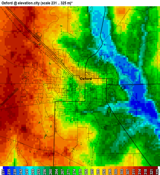
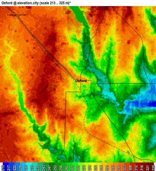
Below is the Elevation map of Oxford, which displays elevation range with different colors. Scale of the first map is from 231 to 325 m (758 to 1066 ft) with average elevation of 282.2 meters (=926 ft) [note 1]
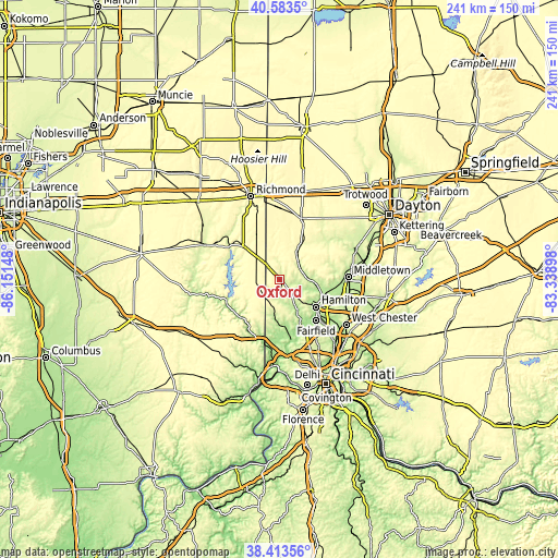
These maps also provides idea of topography and contour of this city, they are displayed at different zoom levels. More info about maps, scale and edge coordinates you can find below images.
| \ | Map #1 | Map #2 | Topo.Map |
| Scale [m] | 231..325 m | 213..325 m | × |
| Scale [ft] | 758..1066 ft | 699..1066 ft | × |
| Average | 282.2 m = 926 ft | 283.3 m = 929 ft | × |
| Width | 7.54 km = 4.7 mi | 15.08 km = 9.4 mi | 241.3 km = 149.9 mi |
| Height | 7.54 km = 4.7 mi | 15.08 km = 9.4 mi | 241.3 km = 149.9 mi |
| ↑Max Latitude | 39.540898° | 39.574779° | 40.5835° |
| Latitude at center | 39.507° | 39.507° | 39.507° |
| ↓Min Latitude | 39.473086° | 39.439155° | 38.41356° |
| ← Min Longitude | -84.789175° | -84.833121° | -86.15148° |
| Longitude center | -84.74523° | -84.74523° | -84.74523° |
| →Max Longitude | -84.701285° | -84.657339° | -83.33898° |
Nearby cities:
Cities around Oxford sort by population:
• Hamilton elevation 186 m
19.8 km,  127°
127°
• Fairfield 185 m
23.9 km,  138°
138°
• Trenton 198 m
24.8 km,  96°
96°
• Eaton 318 m
27.9 km,  19°
19°
• Pleasant Run 230 m
27.8 km,  145°
145°
• Ross 169 m
23.1 km,  159°
159°
• Lake Lakengren 331 m
20.7 km,  12°
12°
• Brookville 206 m
24.8 km,  247°
247°
• New Miami 182 m
19.6 km,  114°
114°
• Liberty 300 m
21.4 km,  311°
311°
• Camden 256 m
15.9 km,  31°
31°
• Dunlap 264 m
26.3 km, 155°
Multilingual:
 En español:
Oxford elevación 280 m.
 En France:
Oxford élévation 280 m.


Sources and notes:
- [note 1] Map square and city borders are not equal. Map elevation data is calculated only from area inside that square.
- [src 1] Elevation data from geonames database provided with same terms of usage.
- [src 2] The elevation map of Oxford is generated using elevation data from NASA's 3 arcsec (90m) resolution SRTM data.
- [src 3] Base (background) map © OpenStreetMap contributors tiles are generated by Geofabrik and OpenTopoMap.
Copyright & License:
This Oxford Elevation Map is licensed under CC BY-SA. You may reuse any part from this page, if you give a proper credit by linking to this URL:
 More info on terms of use page.