Brookville elevation
Brookville (Indiana, Franklin County), United States elevation is 206 meters and Brookville elevation in feet is 676 ft above sea level [src 1]. Brookville is a seat of a second-order administrative division (feature code) with elevation that is 73 meters (240 ft) smaller than average city elevation in United States.
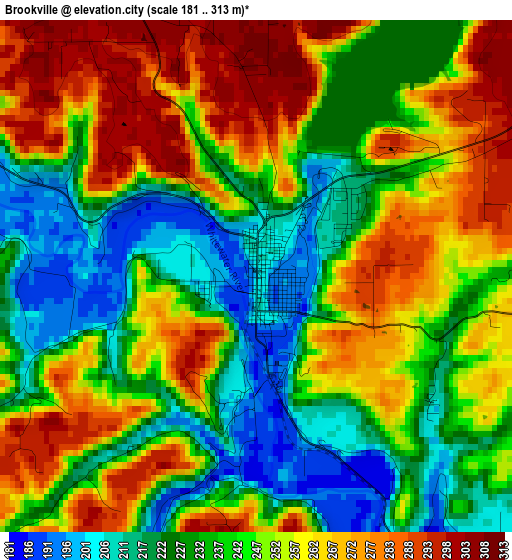
Below is the Elevation map of Brookville, which displays elevation range with different colors. Scale of the first map is from 181 to 313 m (594 to 1027 ft) with average elevation of 246.6 meters (=809 ft) [note 1]
These maps also provides idea of topography and contour of this city, they are displayed at different zoom levels. More info about maps, scale and edge coordinates you can find below images.
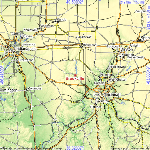
| \ | Map #1 | Topo.Map |
| Scale [m] | 181..313 m | × |
| Scale [ft] | 594..1027 ft | × |
| Average | 246.6 m = 809 ft | × |
| Width | 7.55 km = 4.7 mi | 241.6 km = 150.1 mi |
| Height | 7.55 km = 4.7 mi | 241.6 km = 150.1 mi |
| ↑Max Latitude | 39.457048° | 40.50092° |
| Latitude at center | 39.42311° | 39.42311° |
| ↓Min Latitude | 39.389155° | 38.32837° |
| ← Min Longitude | -85.056685° | -86.41899° |
| Longitude center | -85.01274° | -85.01274° |
| →Max Longitude | -84.968795° | -83.60649° |
Nearby cities:
Cities around Brookville sort by population:
• Oxford elevation 280 m
24.8 km,  67°
67°
• Connersville 251 m
26.6 km,  335°
335°
• Harrison 161 m
24.4 km,  137°
137°
• Batesville 298 m
22.6 km,  232°
232°
• Bright 285 m
26.5 km,  149°
149°
• Hidden Valley 192 m
32.5 km, 153°
• Ross 169 m
33.5 km,  111°
111°
• Liberty 300 m
24.6 km,  16°
16°
• Milan 301 m
35.1 km,  196°
196°
• Grandview 221 m
35.5 km, 135°
• Miamitown 159 m
35.2 km,  130°
130°
• Sunman 311 m
21.9 km, 198°
Multilingual:
 En español:
Brookville elevación 206 m.
 En France:
Brookville élévation 206 m.
 Auf Deutsch:
Brookville höhe über dem Meeresspiegel ist 206 m.

Sources and notes:
- [note 1] Map square and city borders are not equal. Map elevation data is calculated only from area inside that square.
- [src 1] Elevation data from geonames database provided with same terms of usage.
- [src 2] The elevation map of Brookville is generated using elevation data from NASA's 3 arcsec (90m) resolution SRTM data.
- [src 3] Base (background) map © OpenStreetMap contributors tiles are generated by Geofabrik and OpenTopoMap.
Copyright & License:
This Brookville Elevation Map is licensed under CC BY-SA. You may reuse any part from this page, if you give a proper credit by linking to this URL:
 More info on terms of use page.