Batesville elevation
Batesville (Indiana, Ripley County), United States elevation is 298 meters and Batesville elevation in feet is 978 ft above sea level [src 1]. Batesville is a populated place (feature code) with elevation that is 19 meters (62 ft) bigger than average city elevation in United States.
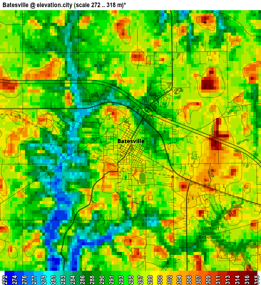
Below is the Elevation map of Batesville, which displays elevation range with different colors. Scale of the first map is from 272 to 318 m (892 to 1043 ft) with average elevation of 294.9 meters (=968 ft) [note 1]
These maps also provides idea of topography and contour of this city, they are displayed at different zoom levels. More info about maps, scale and edge coordinates you can find below images.
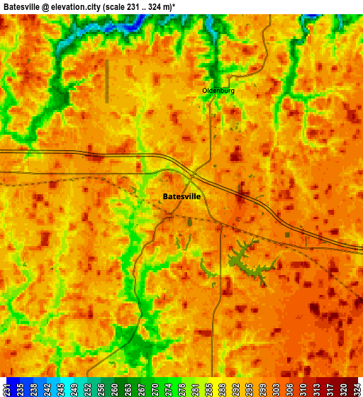
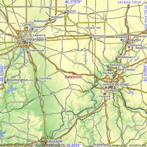
| \ | Map #1 | Map #2 | Topo.Map |
| Scale [m] | 272..318 m | 231..324 m | × |
| Scale [ft] | 892..1043 ft | 758..1063 ft | × |
| Average | 294.9 m = 968 ft | 293.5 m = 963 ft | × |
| Width | 7.56 km = 4.7 mi | 15.12 km = 9.4 mi | 242 km = 150.4 mi |
| Height | 7.56 km = 4.7 mi | 15.12 km = 9.4 mi | 242 km = 150.4 mi |
| ↑Max Latitude | 39.334048° | 39.36803° | 40.37978° |
| Latitude at center | 39.30005° | 39.30005° | 39.30005° |
| ↓Min Latitude | 39.266035° | 39.232004° | 38.2034° |
| ← Min Longitude | -85.266125° | -85.310071° | -86.62843° |
| Longitude center | -85.22218° | -85.22218° | -85.22218° |
| →Max Longitude | -85.178235° | -85.134289° | -83.81593° |
Nearby cities:
Cities around Batesville sort by population:
• Greensburg elevation 292 m
22.9 km,  280°
280°
• Harrison 161 m
34.9 km,  96°
96°
• Bright 285 m
32.8 km,  106°
106°
• Hidden Valley 192 m
36.1 km,  115°
115°
• Greendale 161 m
37.2 km, 124°
• Brookville 206 m
22.6 km,  52°
52°
• Versailles 297 m
25.5 km,  185°
185°
• Milan 301 m
21.4 km,  158°
158°
• Osgood 301 m
19.9 km,  197°
197°
• Westport 247 m
33.2 km,  245°
245°
• Dillsboro 266 m
34.4 km, 155°
• Sunman 311 m
13 km, 122°
Multilingual:
 En español:
Batesville elevación 298 m.
 En France:
Batesville élévation 298 m.
 Auf Deutsch:
Batesville höhe über dem Meeresspiegel ist 298 m.

Sources and notes:
- [note 1] Map square and city borders are not equal. Map elevation data is calculated only from area inside that square.
- [src 1] Elevation data from geonames database provided with same terms of usage.
- [src 2] The elevation map of Batesville is generated using elevation data from NASA's 3 arcsec (90m) resolution SRTM data.
- [src 3] Base (background) map © OpenStreetMap contributors tiles are generated by Geofabrik and OpenTopoMap.
Copyright & License:
This Batesville Elevation Map is licensed under CC BY-SA. You may reuse any part from this page, if you give a proper credit by linking to this URL:
 More info on terms of use page.